LAND, DRONE & AIRBORNE MAGNETIC
Overhauser walking magnetometer-gradiometer MaxiMag
- Highest precision and sensitivity
- Field magnetometer/gradiometer or base station
- Built-in multi-band GNSS receiver and flashlight
- Keypad for right- and left-handed people
- Lightest in the World
- Li-ion battery included
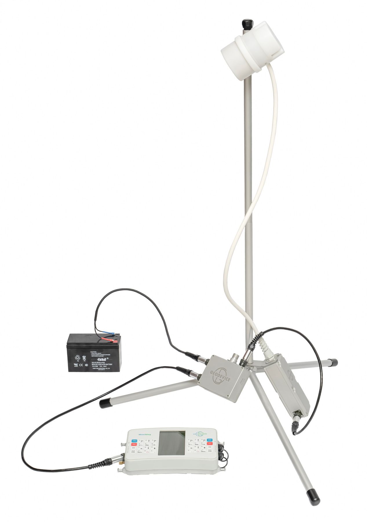
MaxiMag – the World’s most advanced and portable walking Overhauser magnetometer. The instrument is designed to measure magnetic field with high sensitivity and absolute accuracy.
MaxiMag can be used as a walking magnetometer, two- or multi-sensor gradiometer, base station, observatory magnetometer, or even as a GNSS base and rover with centimeter accuracy in PPK mode. Console can be connected to a SmartMag magnetometers and recognizes them as a compatible sensors, so together they can be used as a walking magnetometer and a base station or as a gradiometer.
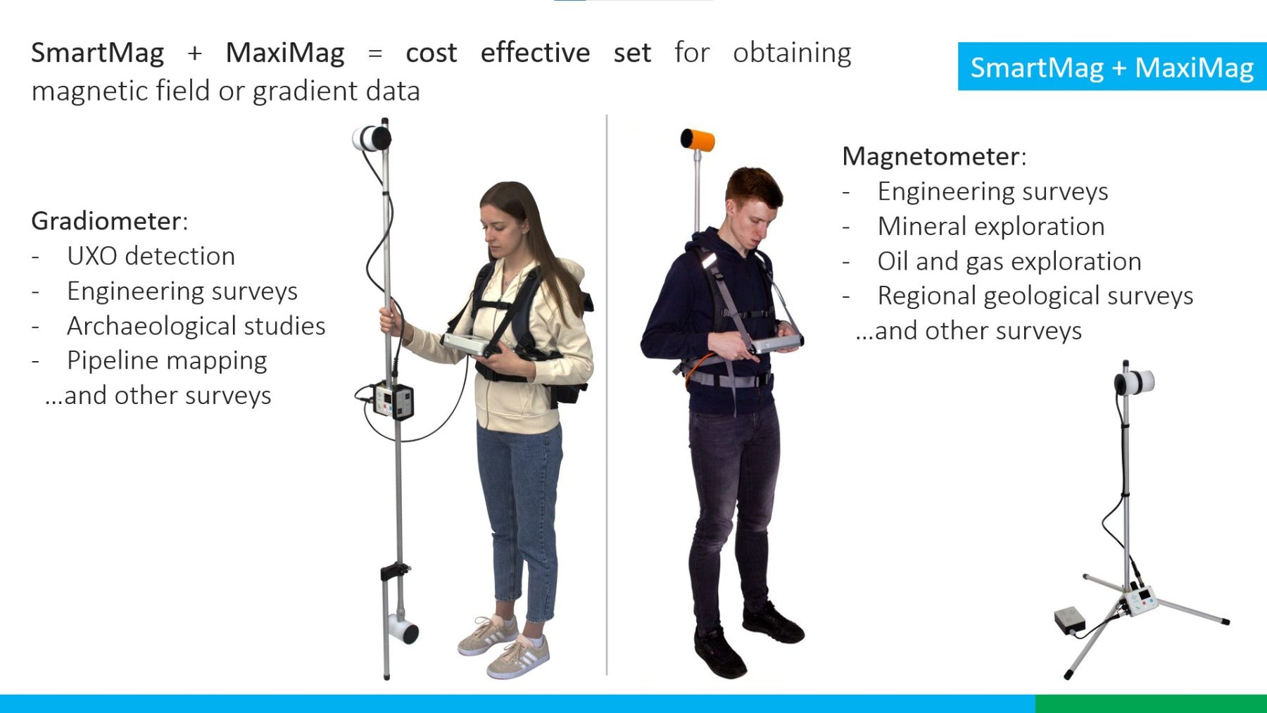
Perfect mobile magnetometer or gradiometer for any task
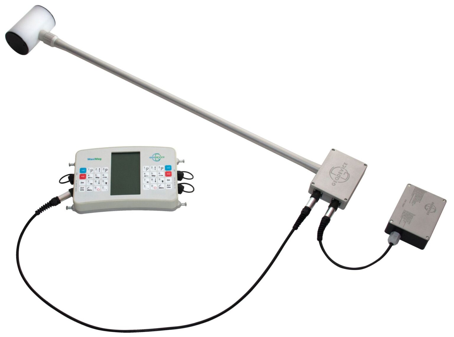
MaxiMag console permits connecting up to 30 digital Overhauser sensors or SmartMag magnetometers via a wired CAN interface. This unique feature enables building two- or multi-sensor gradiometers with the required measurement base and using any console-to-sensor distance.
Optional brackets and frames for any scenarios:
– Brackets for carrying two sensors in hand or in a backpack harness
– Versatile multi-sensor frame for cross-country and shallow water archaeological surveys
– Cart for multi-sensor gradiometer
– Sled for magnetometer and multi-sensor gradiometer
Easy-to-use tablet console
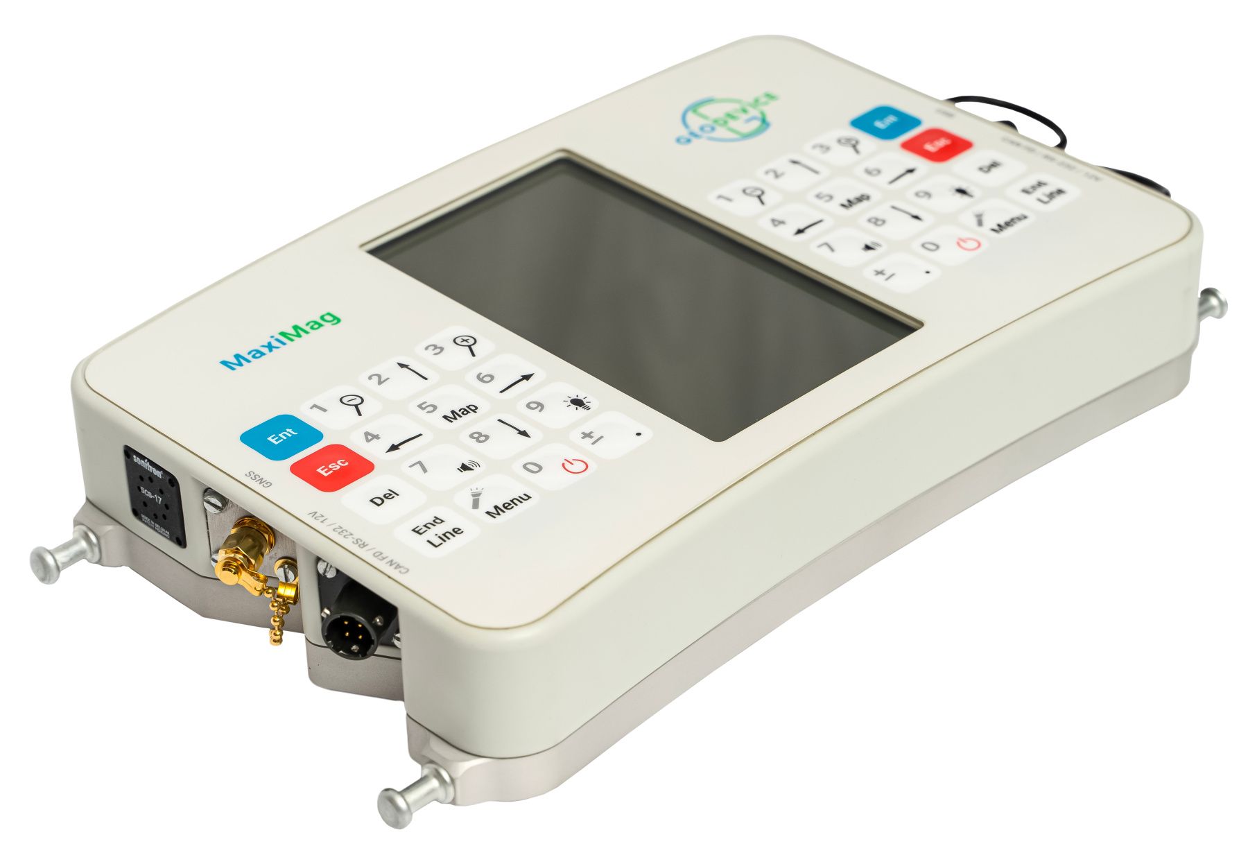
We have equipped the console with large daylight readable and heated display, a two-way keypad, modern wired interfaces and even a flashlight. The control of measured values and their quality is provided in digital, graphical, and audible modes. Line planning, operator guidance, saving of coordinates and exact times of measurements are provided by built-in multi-band GNSS receiver.
When external GNSS receiver is required, MaxiMag supports the standard NMEA-0183 protocol and can be connected to most navigation devices. Data download is available via USB, RS-232 or from the built-in industrial microSD card. We also made sure that all our parts and connectors were non-magnetic, which allowed to reduce the dimensions of the ready-to-go magnetometer set. Maneuvering with a magnetometer in forests and jungles has never been easier!
Magnetometer for magnetic observatories
High sensitivity, sampling rate, and accuracy (less than 0.1 nT) allow to use MaxiMag in magnetic observatories, but a more optimal solution to this problem is provided by the digital SmartMag / OVHmag sensors. Both magnetometers support real-time data broadcasting via CAN FD or RS-232 connection. Optional CAN-Ethernet interface unit can be connected directly to the standard network equipment. The digital CAN FD line can be up to several kilometers long. The device is supplied with the SmartManager software which has all the necessary functionality to work in the INTERMAGNET network of magnetic observatories.
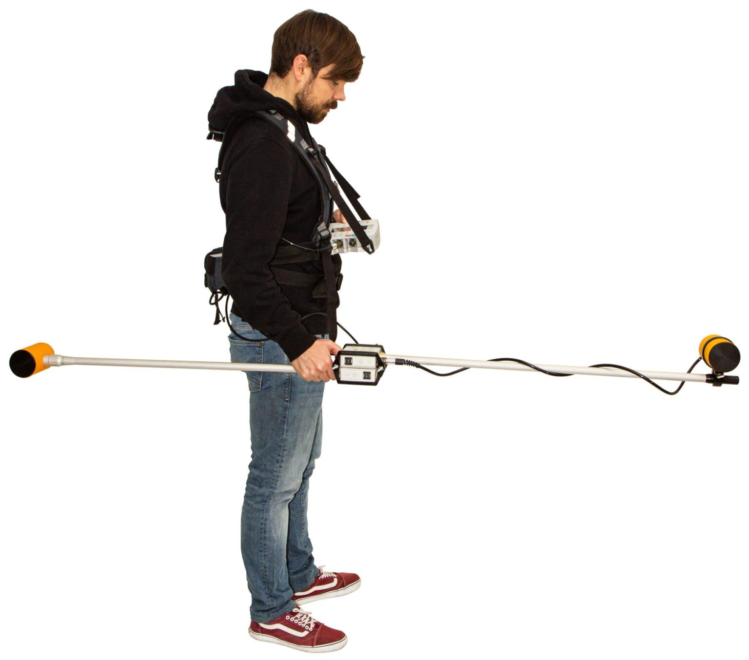
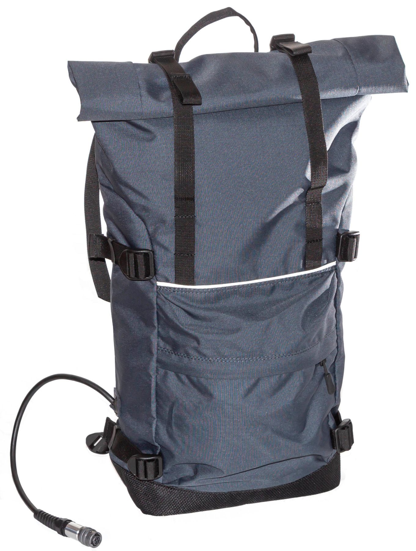
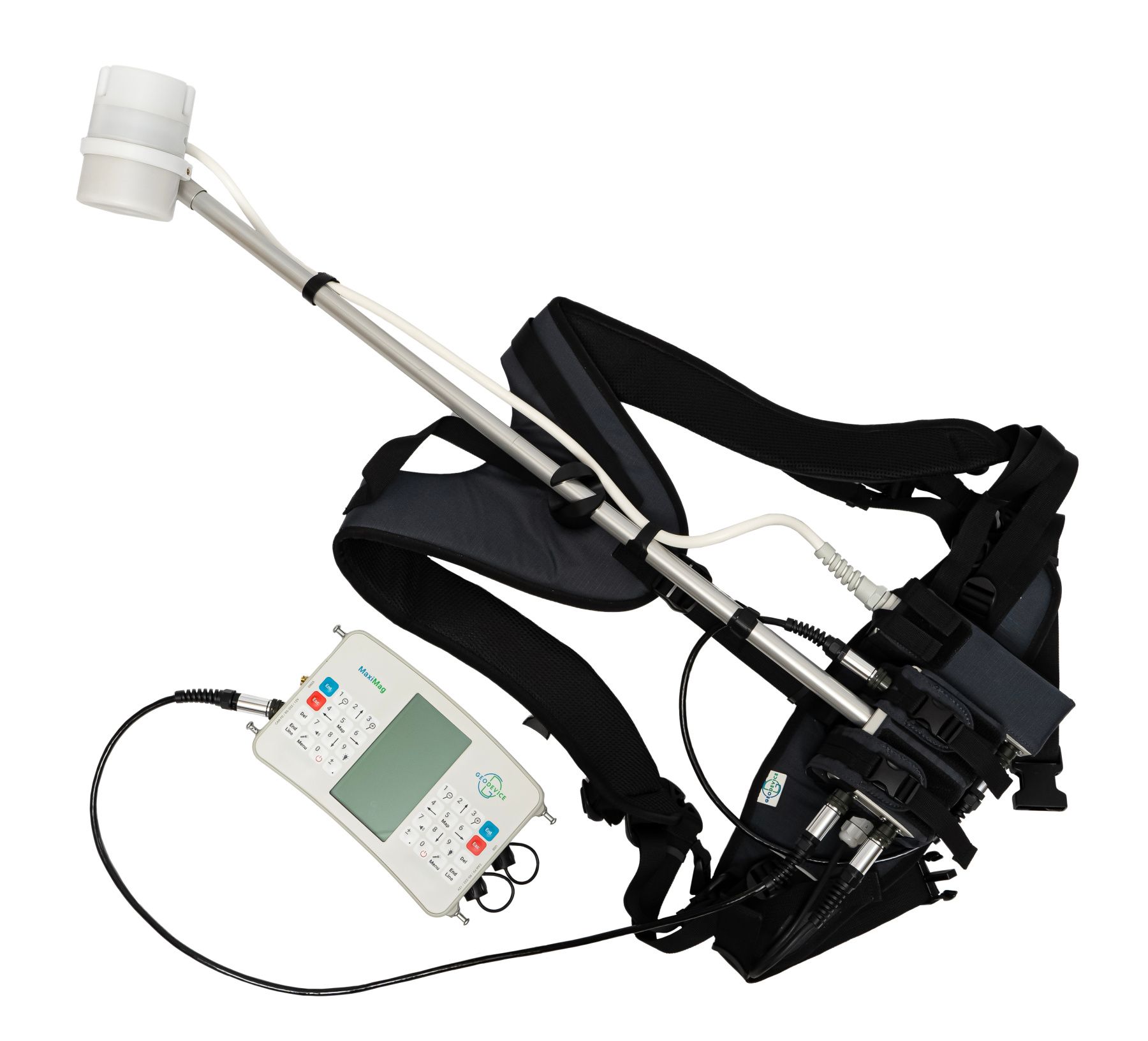
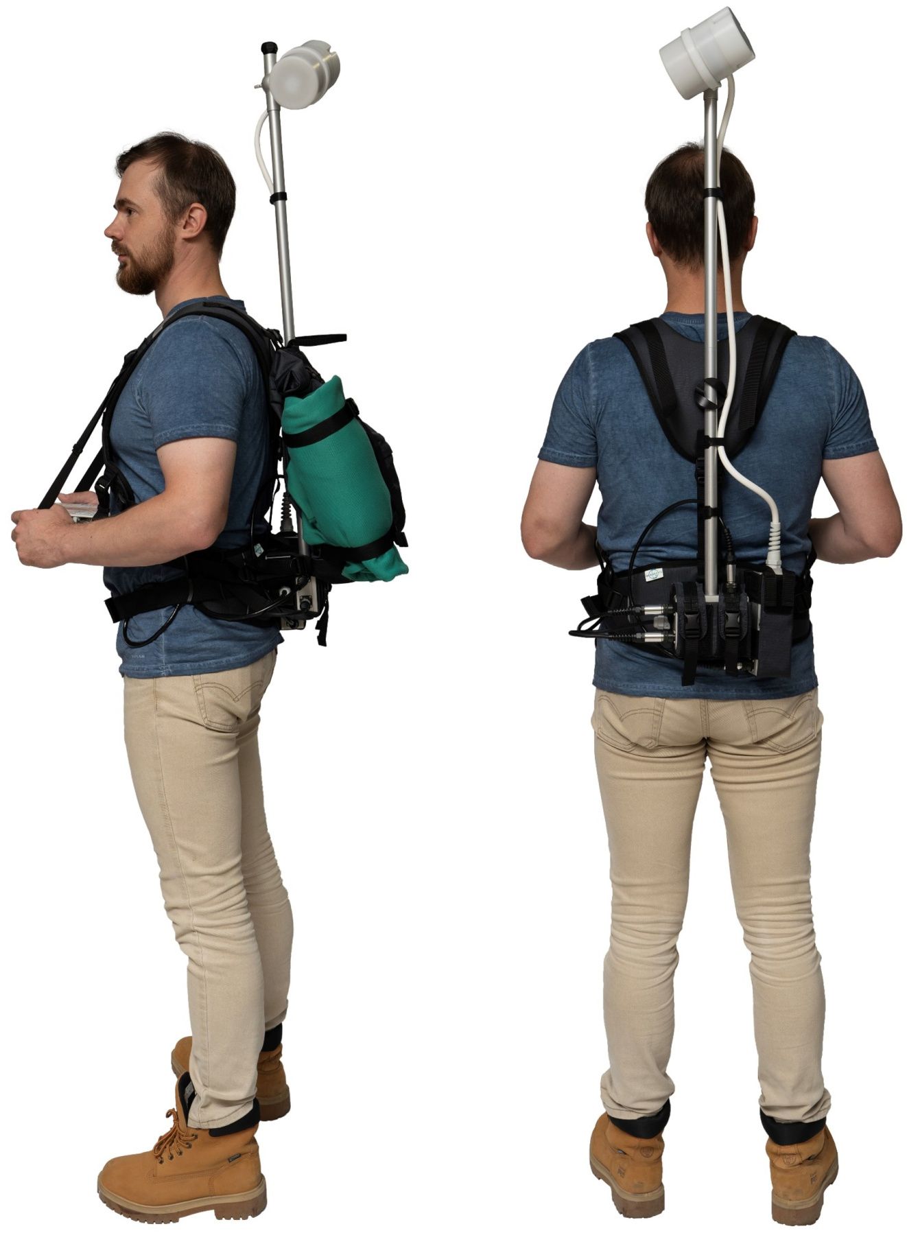
Magnetometer parts and backpack harness
MaxiMag sensors are available in two modifications:
| Modular | Rigid | |
| Sensor vertical orientation | + | – |
| Sensor to electronics module connection | Connector | Permanent |
| Carry-on case | + | – |
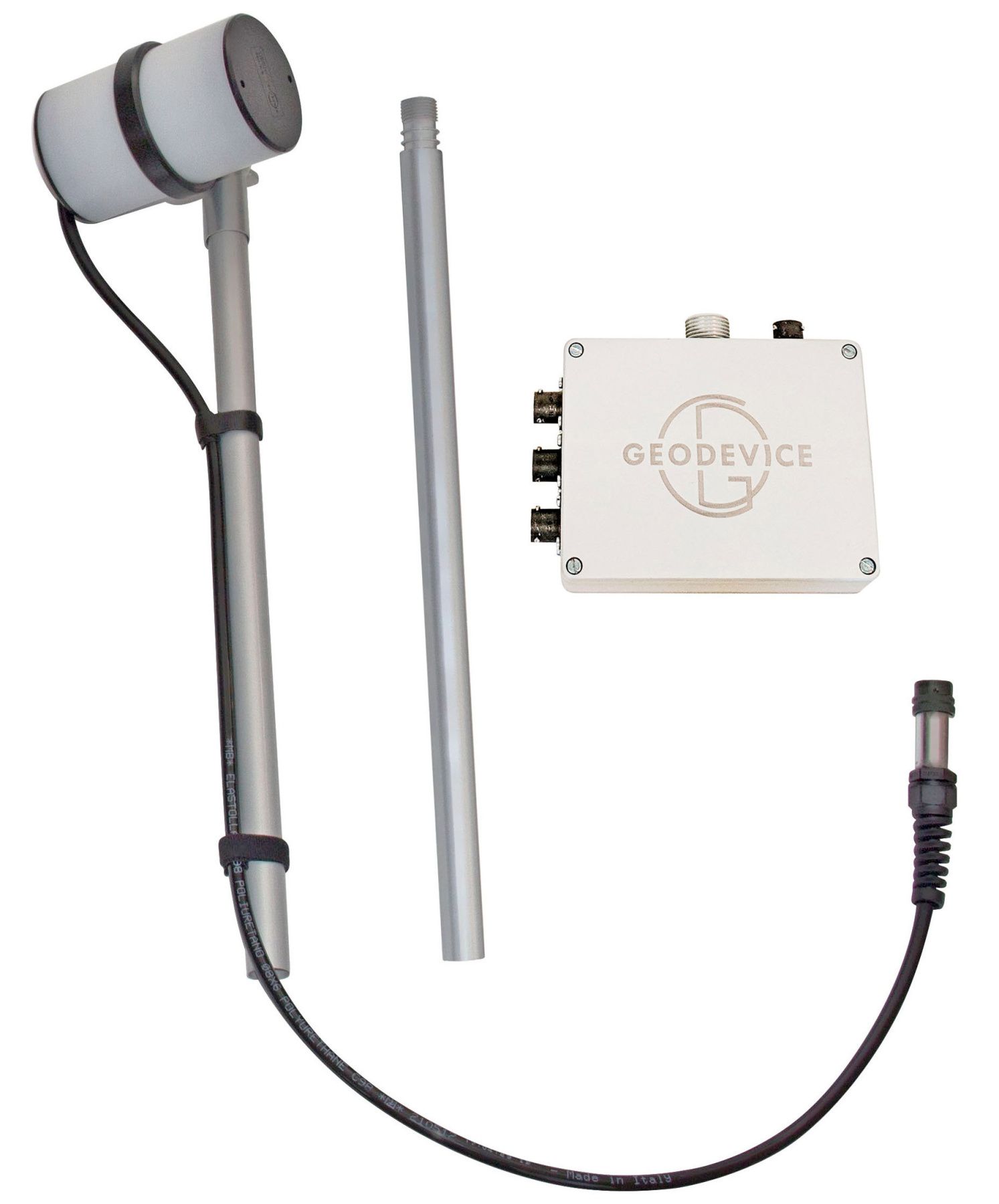
We recommend the rigid design for harsh environments at low temperatures where additional connectors and assembling the sensor with gloves on can be inconvenient. Modular sensors are convenient for use closer to equator and during transportation.
The magnetometer package contains a minimum number of parts to make assembly as easy as possible, but at the same time it consists of all the necessary components, so you do not have to buy additional cables, GNSS receiver and other “options and accessories” required for regular operations. Every magnetometer we ship is ready to be used in its basic configuration. Options add functionality but are not required by most users for standard operating scenarios.
We have also designed an exceptionally comfortable and lightweight harness with plenty of customization to fit anybody. The duffel bag can be unzipped or used to carry an additional battery, clothing or lunch.
Power supply
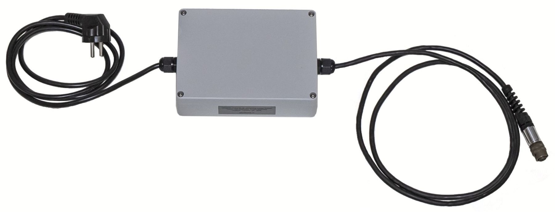
MaxiMag operates over 11 hours of continuous measurements at -30°C from the battery included. At 20°C, the operating time increases to 17 hours. Continuous power supply in long term monitoring mode can be provided with a car battery, an optional low-noise power converter from 110/220VAC to 12VDC, or a solar panel.
Included Li-ion battery has the full temperature range from -40 up to +70°C and MSDS certificate for any kind of transportation.
MaxiMag does not contain built-in batteries, that could complicate air transportation and sooner or later fail and require complex replacement.
Data format
User can create project folders that can be used to divide survey sites or data collection days. All measurements are saved in a TXT file in the project folder. The file from each magnetometer has a name containing the serial number of the console, the code of the measurement mode and the number of connected sensors. The files have a homogeneous structure, i.e. each measurement in the file is a line that contains all necessary information: UTC date and time, time zone, base name or line and station name, measured field, estimated error, sensor serial number, latitude and longitude in decimal degrees, altitude, UTM coordinates with automatic zone and hemisphere selection, horizontal and vertical accuracy. When working with a gradiometer, the line will contain measured field, estimated error, and sensor serial number for each of the connected sensors, and the file name will be different from the magnetometer mode, so the uniformity of the format will not be broken.
Even if there are many operators working on a survey site at the same time, you will always be able to identify which instrument was used for each single measurement in the database.
Metrology and noise protection – a guarantee of high accuracy
Every MaxiMag sensor is metrologically tested. We control the standard deviation of random error (noise), absolute accuracy and heading error.
The robust algorithms allow to perform measurements at high level of industrial noise, in a city environment, or right under high-voltage powerlines.
Reliability and warranty
Our R&D specialists have extensive experience in performing geophysical surveys. We are well aware that such equipment must be reliable, and the service must be fast and comfortable. We give 3 years warranty on all our magnetometers, and our technical support will promptly answer any of your questions. Our Overhauser sensors have the longest in the World lifecycle of more than 10 years. You can also take advantage of our trade-in program and replace your old instruments with the new MaxiMag.
Built-in multi-band GNSS receiver with centimeter level accuracy
Time and coordinates are provided by the built-in multi-band GNSS receiver with PPK feature, which allows to achieve a centimeter level accuracy. Stored RAW GNSS data could be easily converted to RINEX format. The console has GNSS receiver mode and can be used as a GNSS base, rover or tracker without mag sensor connected.
MaxiMag has built-in GNSS antenna and a connector for an external one. It also supports NMEA-0183 protocol and can be connected to external navigation devices via RS-232.
Important “little things”
- Two-way keypad for both right- and left-handed people
- Ultra-bright LED flashlight for safe navigation in the dark
- Built-in multi-band GNSS receiver with PPK feature and base/rover modes
- Superior noise protection allows operation even under power lines
- More than 11 hours of continuous operation at -30°C and 17 hours at 20°C using the battery included
- Power cable for standard lead-acid battery included
Operating modes
- Mobile survey with walking or towed style and station measurements with line guidance
- Base station with continuous measurements
- Search mode for UXO objects detection or evaluation of a base station location
- GNSS receiver mode with ability to collect RAW GNSS data for a centimeter level accuracy with base or rover modes
Application area
- Mineral exploration
- Regional geological surveys
- Engineering surveys
- Pipeline mapping
- UXO detection
- Archaeological studies
- Oil and gas exploration
- Magnetic observatory
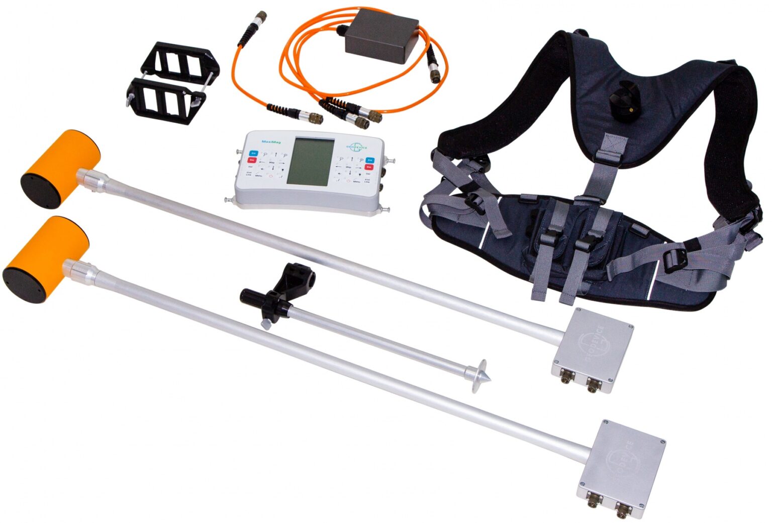
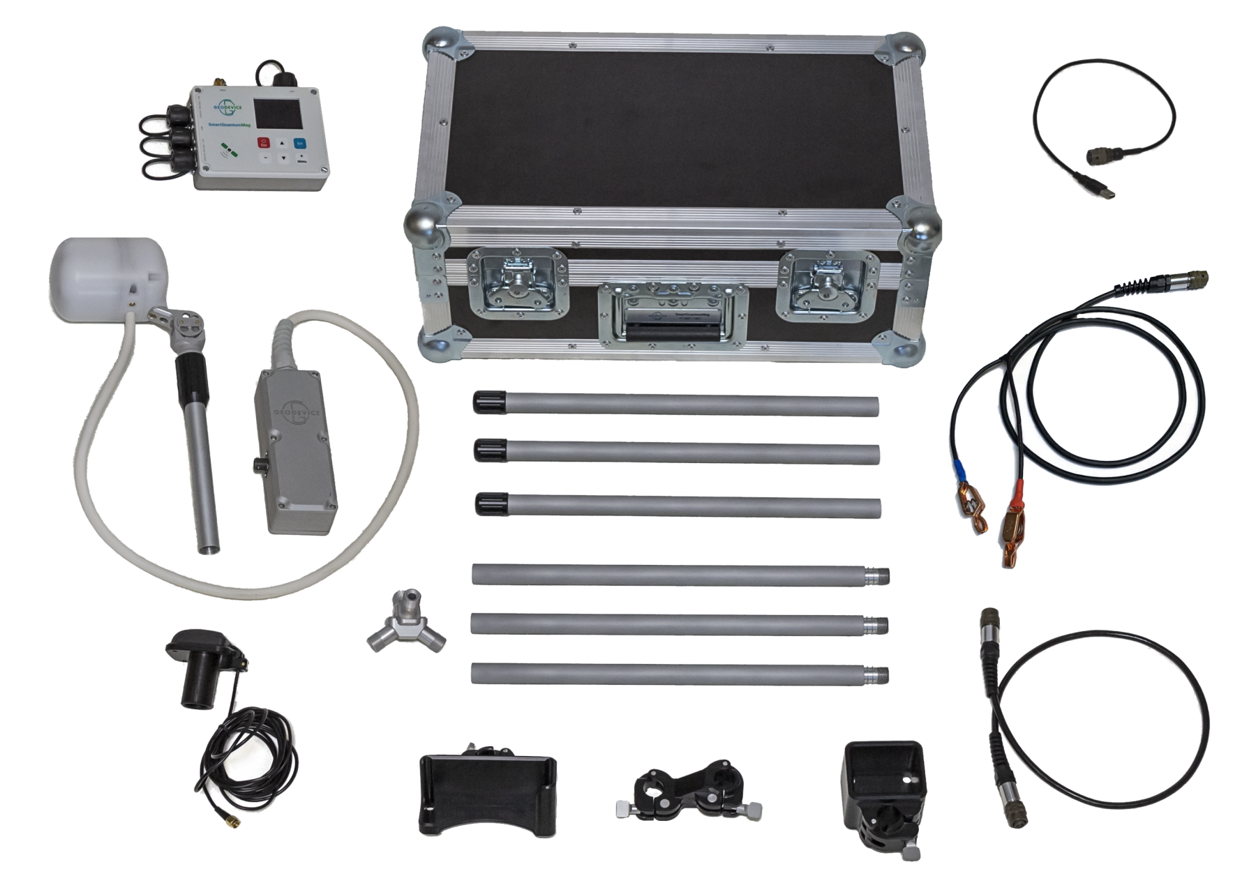
Basic delivery set:
- MaxiMag console with built-in multi-band GNSS receiver
- Digital Overhauser sensor OVHmag
- Li-ion battery 14.8V/4Ah with charger
- Sensor-to-console cable
- AGM battery power cable
- USB cable
- Backpack harness
- Transportation case
Two sensors gradiometer delivery set:
- MaxiMag console with built-in multi-band GNSS receiver
- Digital Overhauser sensor OVHmag – 2 pcs
- Li-ion battery 14.8V/4Ah with charger
- Sensor-to-console cable
- Gradiometer accessories:
– Gradiometer support
– Gradiometer bracket
– Gradiometer cable
– Power cable extension cord - AGM battery power cable
- USB cable
- Backpack harness
- Transportation case

Optional:
- SmartMag base station
- Additional digital Overhauser sensors
- Gradiometer accessories
- Non-magnetic cart for multi-sensor gradiometer
- Non-magnetic tripod
- External GNSS antenna on rod
- Additional Li-ion battery
- CAN-Ethernet interface unit for connecting to PC/router
- RS-232 cable for real-time data broadcasting
- SmartManager software
- Power supply 100-240 VAC
| Type | Overhauser magnetometer |
| Number of sensors | up to 30 |
| Dynamic range | 20 000 to 120 000 nT |
| Absolute accuracy | 0.1 nT |
| Sensor sensitivity | 0.021 nT/√Hz rms0.012 nT/√Hz rms (on request) |
| Resolution | 0.001 nT |
| Gradient tolerance | 30 000 nT/m |
| Sample rates | 0.2, 0.25, 0.5, 1, 2, 3 s and longer with 1 s step |
| Sensors stability | > 10 years |
| Interfaces | built-in: USB, RS-232, CAN FD.optional: Ethernet (CAN-Ethernet interface module) |
| Maximum communication cable length | up to 6 km (CAN FD), up to 100 m (RS-232) |
| GNSS receiver | built-in and optional external |
| GNSS antenna | built-in and optional external |
| GNSS signals | GPS L1C/A and L2C; GLONASS L1OF and L2OF; Galileo E1B/C and E5b; BeiDou B1I and B2I; QZSS L1C/A, L1S and L2C. SBAS: WAAS, EGNOS, MSAS, GAGAN. |
| Connectors | 2 × CAN FD+12V / RS232+12V, USB, external GNSS antenna |
| Display | 240 × 128, LCD |
| Membrane switch panel | 32 buttons |
| Internal memory capacity | up to 32 Gb (industrial microSD) |
| Power | 9.5-21 VDC, LiPo 3S/4S, Li-ion 3S/4S, LiFePo4 4S, or lead-acid battery 100-240 VAC, optional power unit required |
| Operating temperature | –40 to +60 °C |
| Li-ion battery | 14.6 V, 4 A·h |
| Flashlight | LED, 300 lumens |
| Dimensions with connectors | 930×125×72 mm – rigid sensor 940×130×105 mm – assembled modular sensor 260×150×45 mm – console |
| Item weight | 1.1 kg – console 1.4 kg – rigid sensor 1.5 kg – modular sensor 0.7 kg – Li-ion battery |
| Weight of a set includes console, sensor, Li-ion battery, harness and sensor cable | 4 kg – magnetometer with rigid sensor 6 kg – gradiometer with rigid sensors |
| Delivery package size and weight | 100 × 20 × 25 cm, 14 kg – magnetometer with rigid sensor 100 × 20 × 31 cm, 17 kg – gradiometer with rigid sensors 55.8 × 35.5 × 19 cm, 8.5 kg – magnetometer with modular sensor 62.5 × 50 × 29.7 cm, 17 kg – gradiometer with modular sensors |
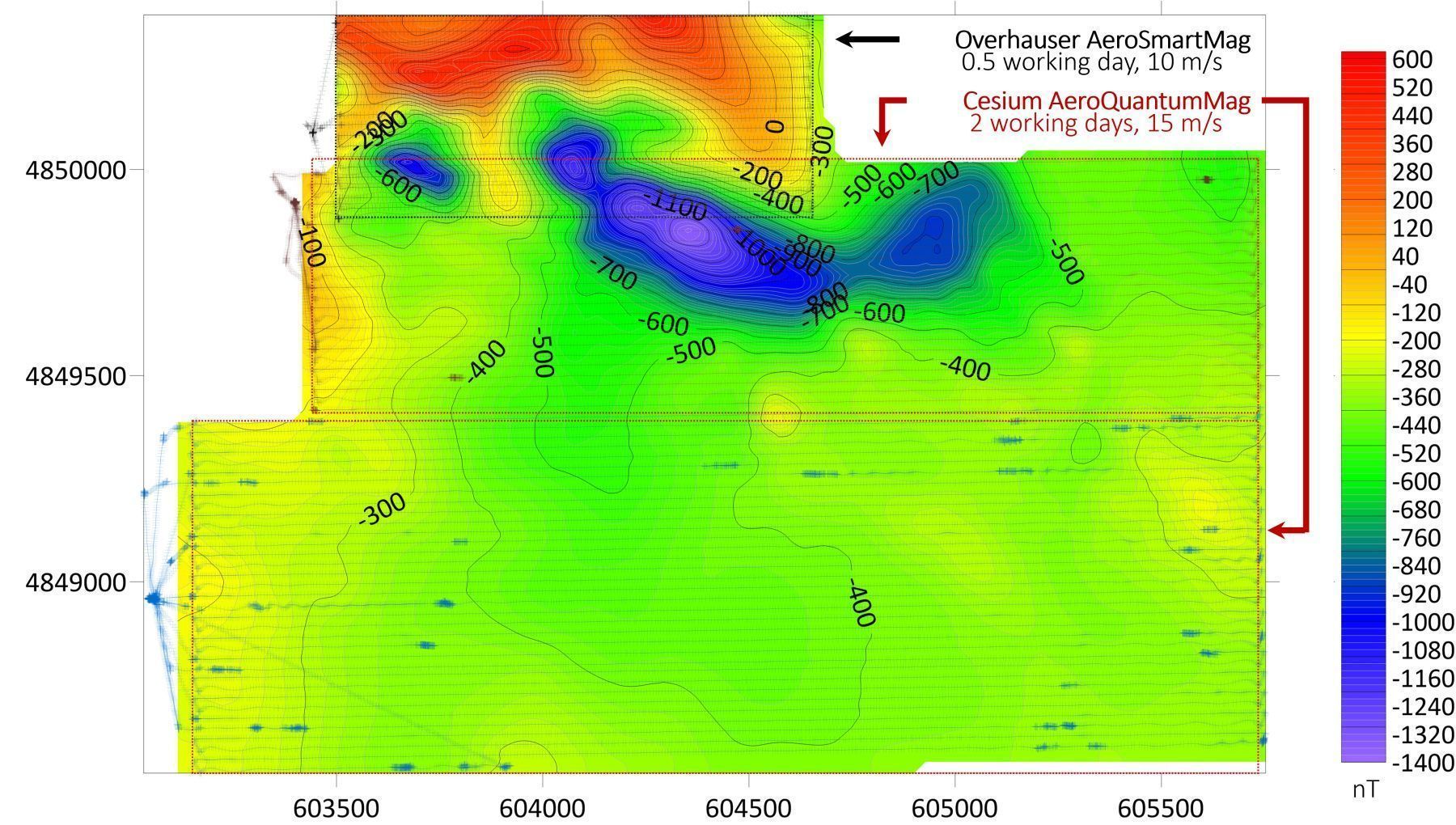
Cesium walking magnetometer-gradiometer QuantumMag
- Very fast – up to 100 readings per second
- Effective in noisy conditions
- Built-in multi-band GNSS receiver and flashlight
- Keypad for right- and left-handed people
- Lightest in the World
- LiFePo4 battery included
QuantumMag is one of the most advanced and lightweight walking Cesium magnetometers on the market. The system allows to measure the Earth’s total magnetic field with highest sensitivity and sample rate up to 100 Hz. The device can be used as a walking magnetometer, gradiometer, base station, or even as a GNSS base and rover with centimeter accuracy in PPK mode. Console can be connected to a SmartQuantumMag magnetometer and recognizes it as a compatible digital sensor, so together they can be used as a walking magnetometer and a base station or as a gradiometer.
Perfect mobile magnetometer or gradiometer for any task
MaxiMag console permits connecting up to 6 digital Cesium magnetometers via a wired CAN interface. This unique feature enables building two- or multi-sensor gradiometers with the required measurement base and use any console-to-sensor distance.
Optional brackets and frames for any scenarios:
– Brackets for two sensors for carrying them in hand or in a backpack harness
– Versatile multi-sensor frame for cross-country and shallow water archaeological surveys
– Cart for multi-sensor gradiometer
– Sled for magnetometer and multi-sensor gradiometer
Easy-to-use tablet console
We have equipped the console with large daylight readable and heated display, two-way keypad, modern wired interfaces and even a flashlight. The control of measured values and their quality is provided in digital, graphical, and audible modes. Line planning, operator guidance, saving of coordinates and exact times of measurements are provided by built-in multi-band GNSS receiver.
In some cases, external GNSS receiver is required – MaxiMag supports the standard NMEA-0183 protocol and can be connected to most navigation devices. Data download is available via USB, RS-232 or from the built-in industrial microSD card. We also made sure that all our parts and connectors were non-magnetic, which allowed to reduce the dimensions of the ready-to-go magnetometer set. Maneuvering with a magnetometer in forests and jungles has never been easier!
UXO and utility detection
QuantumMag can be used as a deep metal detector and utility locator due to its high sample rate and graphics on display. This makes it perfect for the deep unexploited ordnance (UXO) detection and geotechnical studies.
Sensor can be carried in the backpack harness (regular survey) or at the shoulder belt (e.g. for UXO and utility detection) depending on the selected survey technique.
Magnetometer parts and backpack harness
The magnetometer package contains on one hand a minimum of unified parts to ease the assembly and use, and on the other – all necessary components, so that you do not have to buy additional cables, a battery, or GNSS receiver without which you will not be able to work. Every magnetometer we ship is ready to use in its basic configuration. Options add functionality, but are not required by most users for standard operating scenarios.
We have also designed an exceptionally comfortable and lightweight harness with plenty add-ons to fit anybody. The duffel bag can be unzipped or used to carry an additional battery, clothing or lunch.
Power supply
QuantumMag operates over 8 hours of continuous measurements at -30°C from the battery included. At 20°C, the operating time increases to 17 hours. Continuous power supply in long term monitoring mode can be provided with a car battery, an optional low-noise power converter from 110/220VAC to 12VDC, or a solar panel.
Included LiFePo4 battery has the full temperature range from -40 up to +60°C and MSDS certificate for any kind of transportation.
QuantumMag does not contain built-in batteries, which might complicate air transportation and sooner or later fail and require complex replacement.
Data format
User can create project folders that can be used to divide survey sites or data collection days. All measurements are saved in a TXT file in the project folder. The file from each magnetometer has a name containing the serial number of the console, the code of the measurement mode and the number of connected sensors. The files have a homogeneous structure, i.e. each measurement in the file is a line that contains all necessary information: UTC date and time, time zone, base name or line and station name, measured field, estimated error, sensor serial number, latitude and longitude in decimal degrees, altitude, UTM coordinates with automatic zone and hemisphere selection, horizontal and vertical accuracy. When working with a gradiometer, the line will contain measured field, estimated error, and sensor serial number for each of the connected sensors, and the file name will be different from the magnetometer mode, so the uniformity of the format will not be broken.
Even if there are many operators working on a survey site at the same time, you will always be able to identify which instrument was used for each single measurement in the database.
Metrology and noise protection – a guarantee of high accuracy
Every Cesium QuantumMag sensor is metrologically tested. We control the standard deviation of random error (noise), absolute accuracy and heading error.
The robust algorithms allow performing measurements at high level of industrial noise, in a city environment, or right under high-voltage powerlines.
Reliability and warranty
Our R&D specialists have extensive experience in performing geophysical surveys. We are well aware that such equipment must be reliable, and the service must be fast and comfortable. We give 3 years warranty on all our magnetometers, and our technical support will promptly answer any of your questions. You can also take advantage of our trade-in program and replace your old instruments with the new MaxiMag with discounts.
Built-in multi-band GNSS receiver with centimeter level accuracy
Time and coordinates are provided by the built-in multi-band GNSS receiver with PPK feature, which permits to achieve a centimeter level accuracy. Stored RAW GNSS data could be easely converted to RINEX format.
The console has GNSS receiver mode and can be used as a GNSS base, rover or tracker without mag sensor connected.
MaxiMag has built-in GNSS antenna and a connector for an external one. It also supports NMEA-0183 protocol and can be connected to external navigation devices via RS-232.
Important “little things”
- Carry-on size transportation case with whole equipment setup weight 9 kg only
- Two-way keypad for both right- and left-handed people
- Ultra-bright LED flashlight for safe navigation in the dark
- Superior noise protection allows operation even under power lines
- More than 8 hours of continuous operation at -30°C and 17 hours at 20°C using the battery included
- Power cable for standard lead-acid battery included
Operating modes
- Mobile survey with walking or towed style and station measurements with line guidance
- Base station with continuous measurements
- Search mode for UXO objects detection or evaluation of a base station location
- GNSS receiver mode with ability to collect RAW GNSS data for a centimeter level accuracy with base or rover modes
Application area:
- Mineral exploration
- UXO detection
- Regional geological surveys
- Engineering surveys
- Pipeline mapping
- Archaeological studies
- Oil and gas exploration
Delivery set:
- MaxiMag console with built-in multi-band GNSS receiver
- CMx sensor on rod
- Sensor electronics QuantumMag
- Counter QuantumMag
- Lithium battery with charger
- Sensor-to-console cable
- Battery power cable
- USB cable
- Non-magnetic rod
- Backpack harness
- Transportation case
Two-sensors gradiometer delivery set:
- MaxiMag console with built-in multi-band GNSS receiver
- CMx sensor on rod (2 pcs)
- Sensor electronics QuantmMag (2 pcs)
- Counter QuantumMag (2 pcs.)
- Gradiometer accessories
- Lithium battery (2 pcs) with charger
- Sensor-to-console cable
- Battery power cable
- USB cable
- Non-magnetic rod (2 pcs.)
- Backpack harness
- Transportation case
Optional:
- SmartQuantumMag base station
- Additional digital CMx sensors
- Gradiometer accessories
- Non-magnetic cart for multi-sensor gradiometer
- Non-magnetic tripod
- External GNSS antenna on rod
- CAN-Ethernet interface unit for connecting to PC/router
- RS-232 cable for real-time data broadcasting
- SmartManager software
- Power supply 100-240 VAC
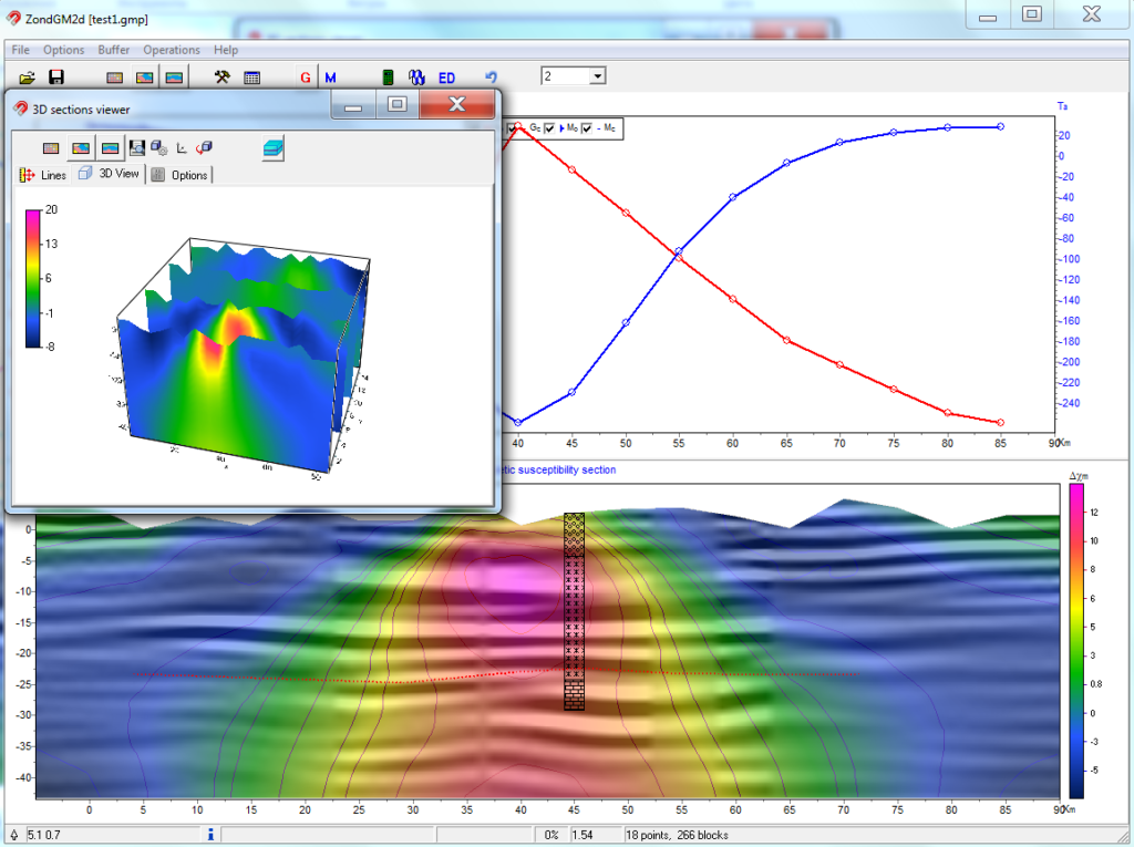
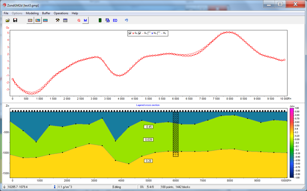
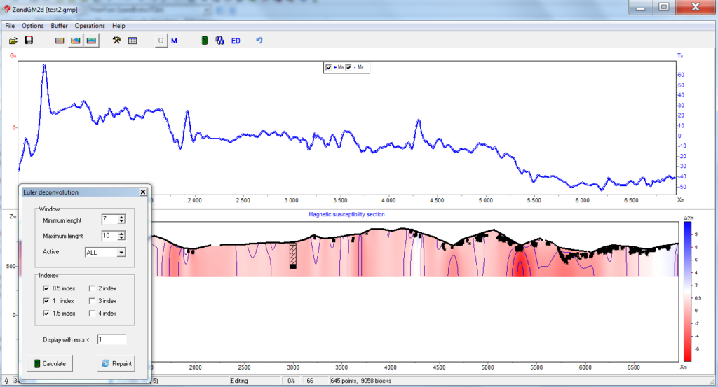
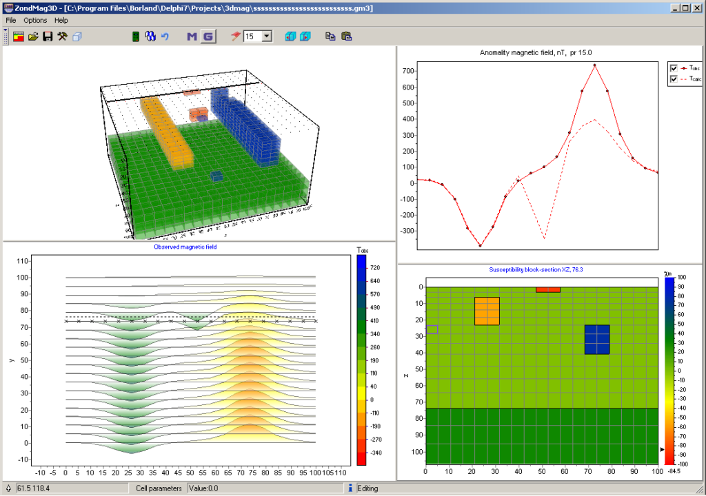
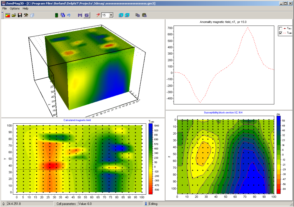
Magnetometry survey forward modelling and data inversion may be successfully performed with advanced ZondGM2d and ZondGM3d software packages.
| Type | Optical pumped Cs magnetometer |
| Number of sensors | up to 6 |
| Dynamic range | 15 000 to 110 000 nT |
| Absolute accuracy | 2 nT |
| Sensor sensitivity | 0.002 nT/√Hz rms 0.021 nT/√Hz rms (on request) |
| Resolution | 0.001 nT |
| Gradient tolerance | 20 000 nT/m |
| Sample rates | up to 100 Hz |
| Additional sensors | IMU, compass |
| Interfaces | built-in: USB, RS-232, CAN FD. optional: Ethernet (CAN-Ethernet interface unit required) |
| Maximum communication cable length | up to 6 km (CAN FD), up to 100 m (RS-232) |
| GNSS receiver | built-in and optional external |
| GNSS antenna | built-in and optional external |
| GNSS signals | GPS L1C/A and L2C; GLONASS L1OF and L2OF; Galileo E1B/C and E5b; BeiDou B1I and B2I; QZSS L1C/A, L1S and L2C. SBAS: WAAS, EGNOS, MSAS, GAGAN connection of external receiver via RS-232 |
| Connectors | 2 × CAN FD+12V / RS232+12V, USB, external GNSS antenna |
| Display | 240 × 128, LCD with heater |
| Keypad | 32 buttons |
| Built-in memory | up to 32 Gb (microSD) |
| Power supply | 9.5-21 VDC, LiPo 3S/4S, Li-ion 3S/4S, LiFePo4 4S, or lead-acid battery 100-240 VAC, optional power unit required |
| Operating temperature | –40 to +60 °C |
| Battery included | 12.8 V, 7.5 A·h |
| Flashlight | LED, 300 lumens |
| Dimensions with connectors | Ø82×120 mm – CMx sensor 260×150×45 mm – console |
| Item weight | 1.1 kg – console 1.2 kg – sensor on rod with sensor electronics 0.4 kg – counter 1.3 kg – LiFePo4 battery |
| Weight of a set includes console, sensor, battery, harness and sensor cable | 4.8 kg – magnetometer 7.0 kg – gradiometer |
| Delivery package size and weight | 55.8 × 35.5 × 19 cm, 8.5 kg – magnetometer 62.5 × 50 × 29.7 cm, 18 kg – gradiometer |
| Delivery package size and weight | 62.9 × 39.3 × 20.9, 9 kg |
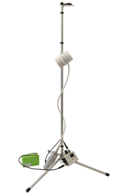
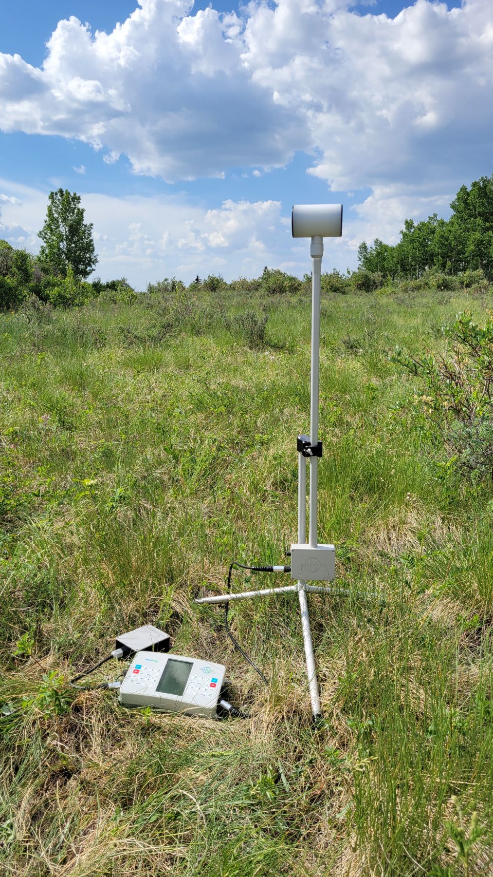
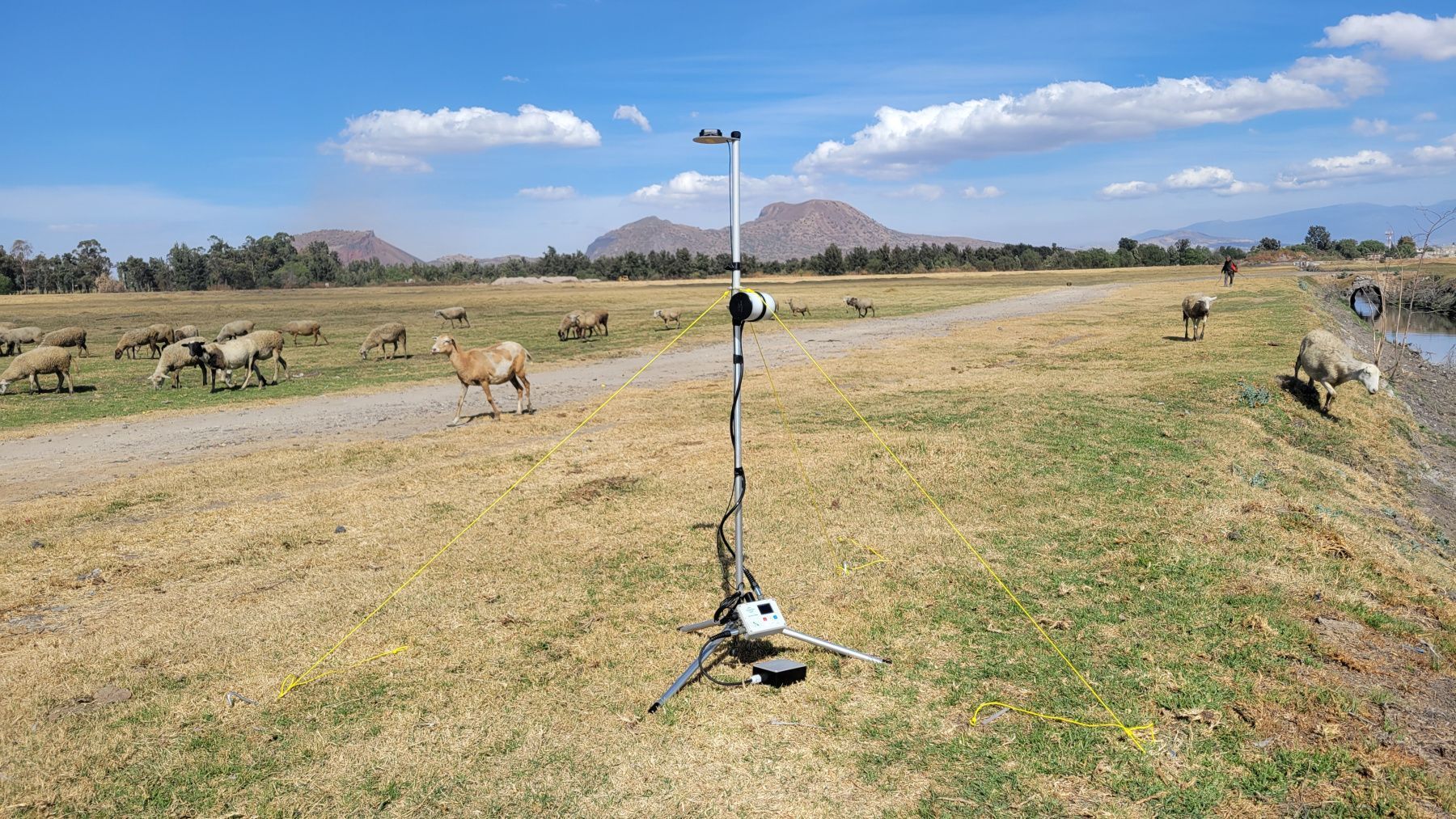
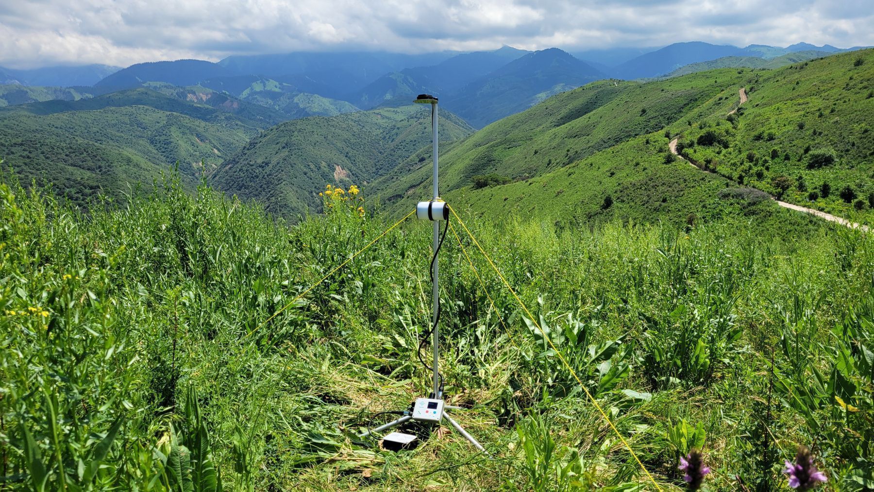
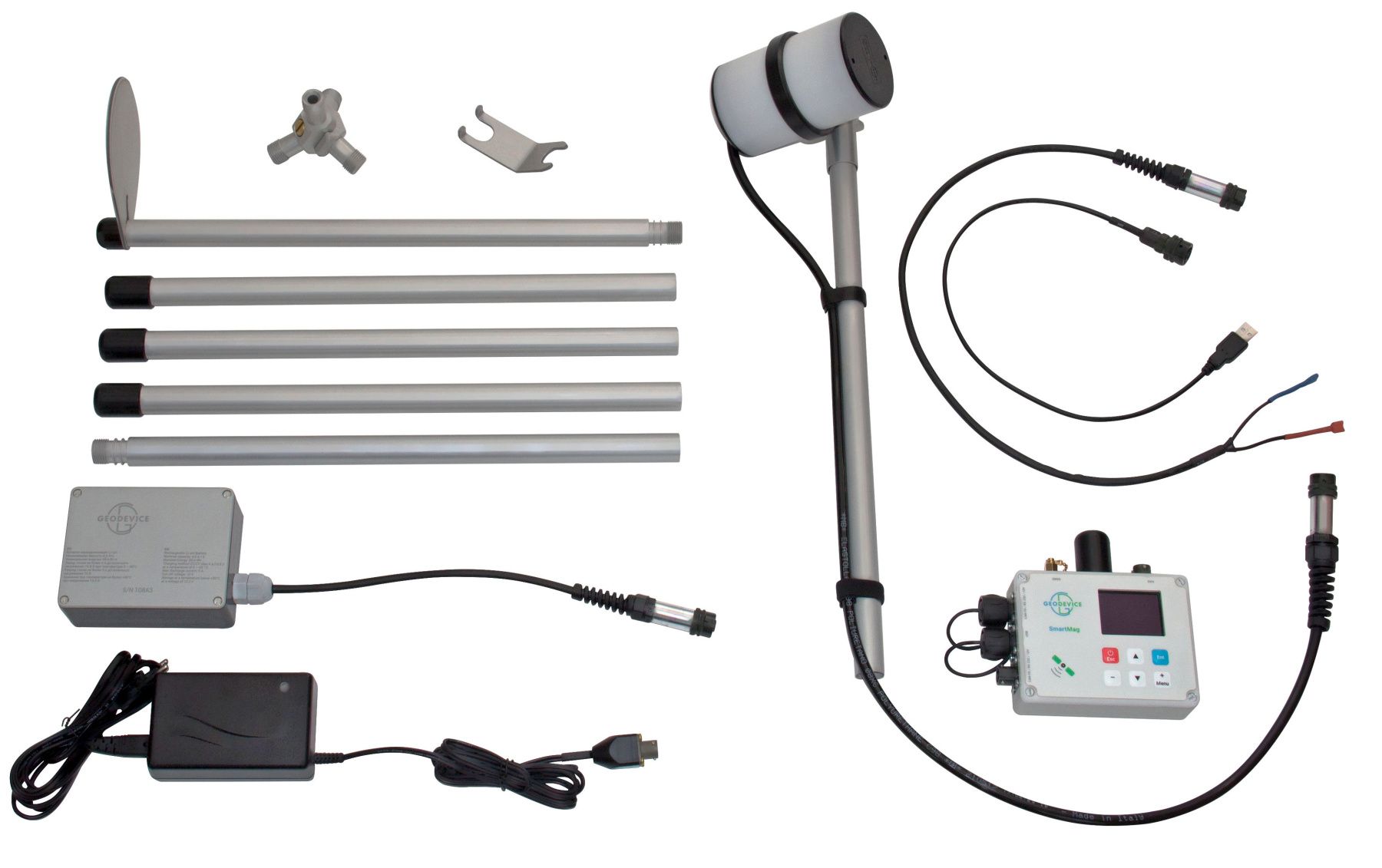
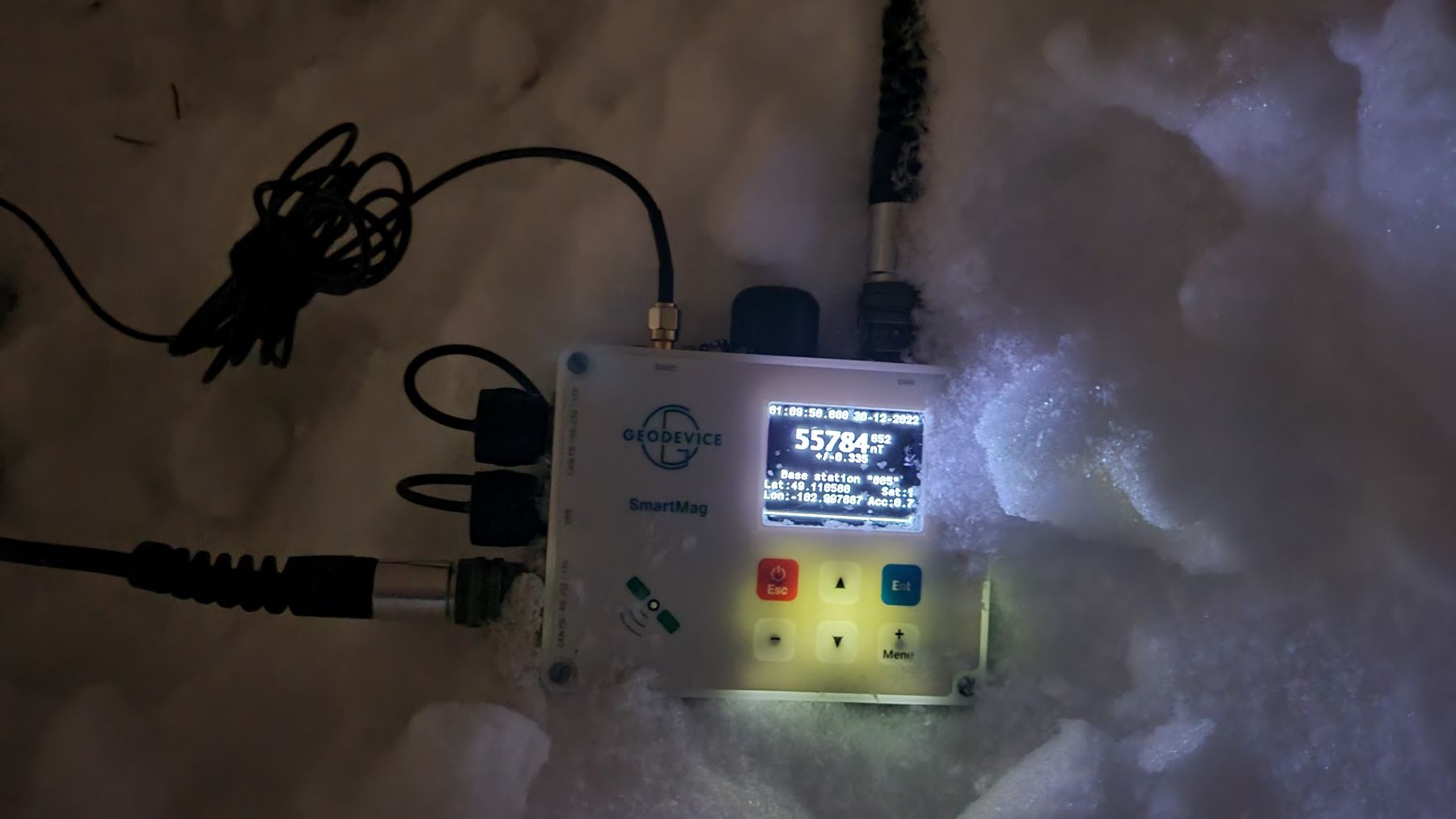
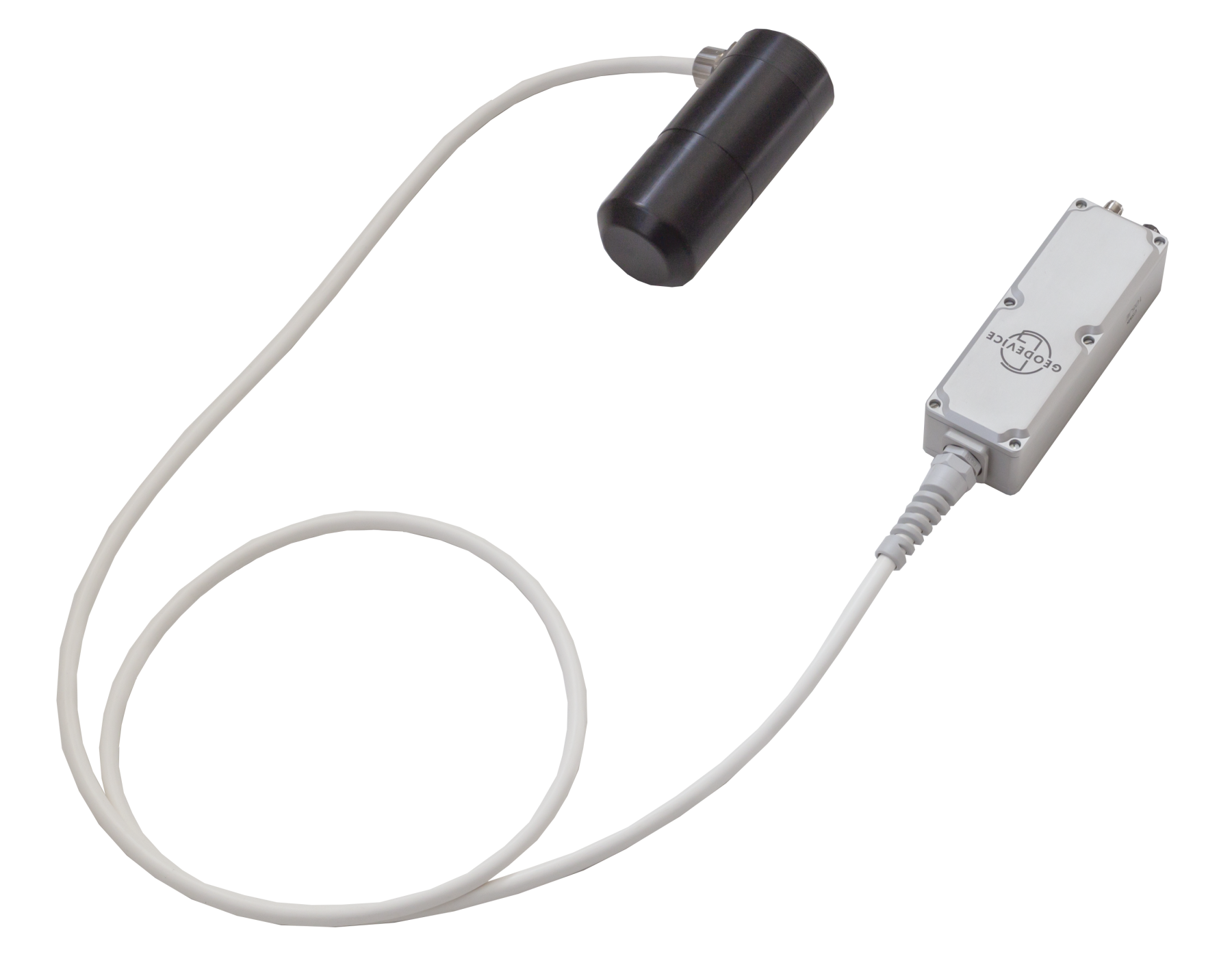
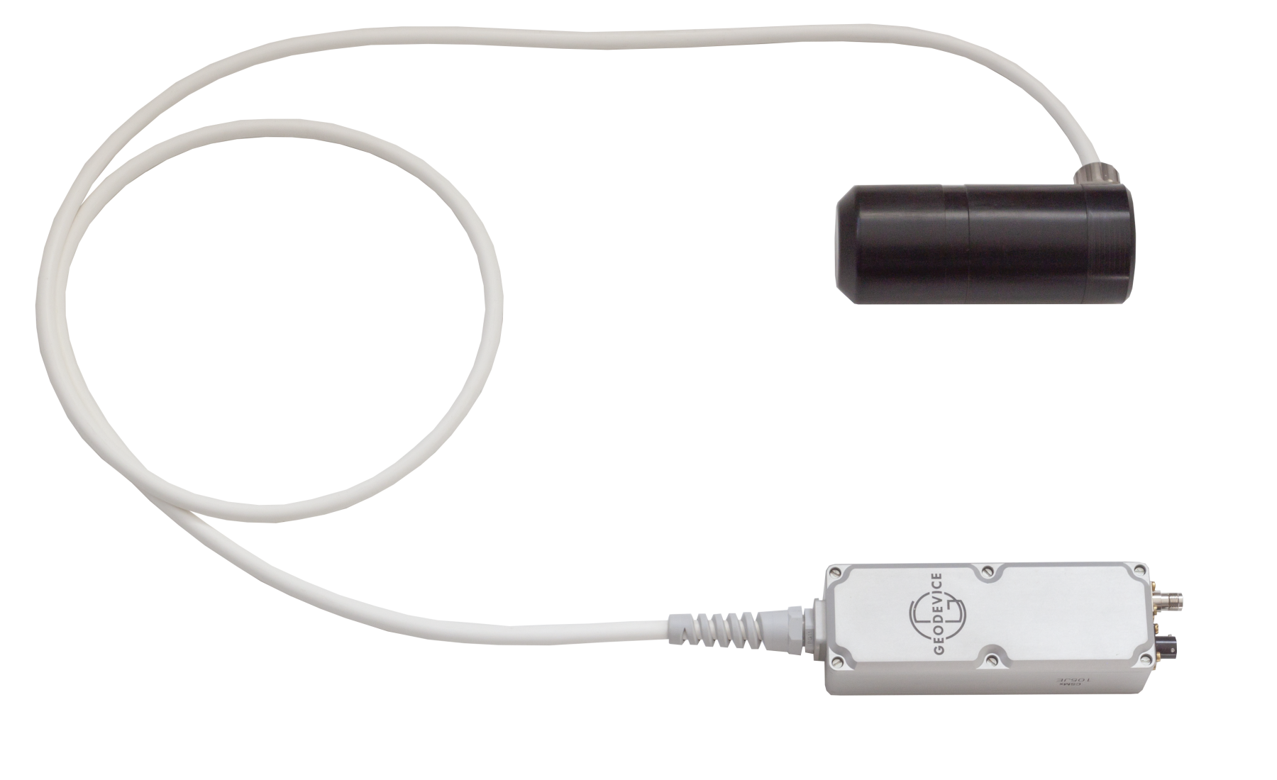
Overhauser base station magnetometer SmartMag

- High precision and sensitivity
- The World’s most compact base station magnetometer
- Optimal for operation in magnetic observatories
- Several SmartMags can be combined into gradiometer
- Built-in multi-band GNSS receiver with PPK feature
SmartMag – the World’s most advanced and portable magnetometer based on the Overhauser effect. The complete ready to use set with all necessary accessories and battery fits in a carry-on size case and weighs only 7.5 kg. SmartMag can be used as an observatory magnetometer, base station, as part of a multi-sensor gradiometer, or even as a GNSS base and rover with centimeter accuracy in PPK mode. It is fully compatible with MaxiMag console and can be applied for any type of ground magnetic surveys.
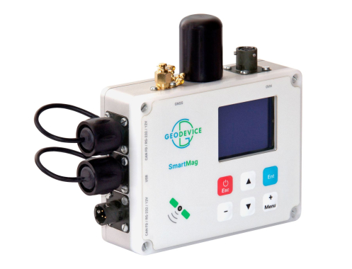
Easy-to-use console
The console enables easy configuration of operating modes, visual control of measured values and viewing of stored data from the built-in microSD card. Downloading data is performed via USB to a PC or smartphone. It is also possible to broadcast data via RS-232 or CAN ports in real time mode. The console is equipped with an OLED display (-40 ÷ +60 °C), built-in multi-band GNSS receiver with RAW GNSS data collection, and backlit keypad.
Magnetometer for magnetic observatories
High sensitivity, sampling rate, and accuracy (less than 0.1 nT) makes SmartMag one of the best magnetometers for magnetic observatories. Real-time data broadcasting realized via CAN FD or RS-232 connection. With the optional CAN-Ethernet interface unit SmartMag can be connected directly to network. The digital CAN FD cable can be up to several kilometers long. The device is supplied with the SmartManager software that has all the necessary functionality to perform measurements in the INTERMAGNET network of magnetic observatories.
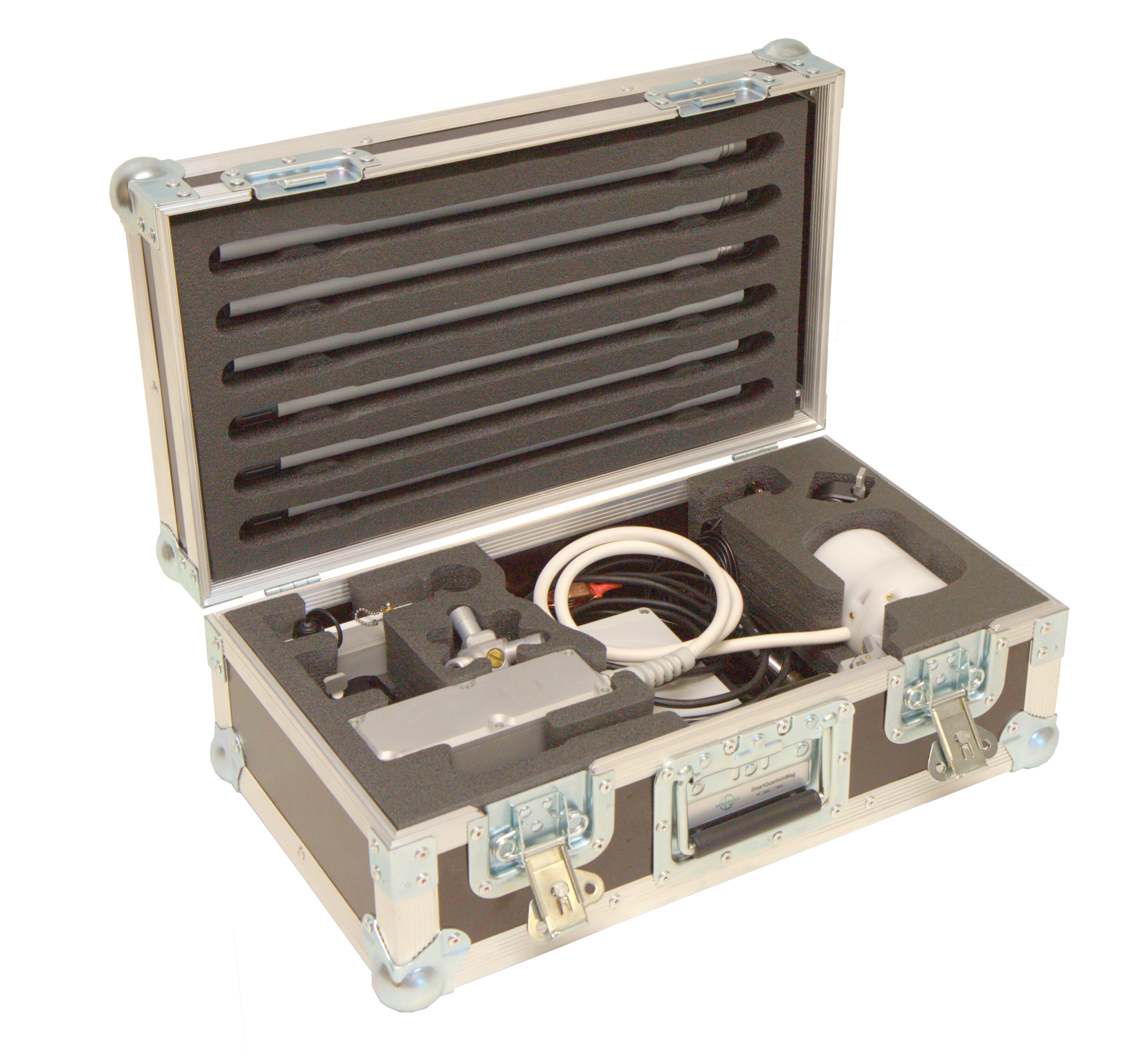
Magnetometer parts
The magnetometer package contains on the one hand a minimum number of unified parts to ease assembly and use, and on the other hand all the necessary components, so that you do not have to buy additional cables, a battery, or GNSS receiver without which you will not be able to work.
Every magnetometer we ship is ready to use in its basic configuration. Options add functionality, but are not required by most users for standard operating scenarios.
Power supply
SmartMag operates over 12 hours of continuous measurements at -30°C from the battery included. At 20°C, the operating time increases to 23 hours. Continuous power supply in long term monitoring mode can be provided with a car battery, an optional low-noise power converter from 110/220VAC to 12VDC, or a solar panel.
Included Li-ion battery has the full temperature range from -40 up to +70°C and MSDS certificate for any kind of transportation.
SmartMag does not contain built-in batteries, which complicate air transportation and sooner or later fail and require complex replacement.

Data format
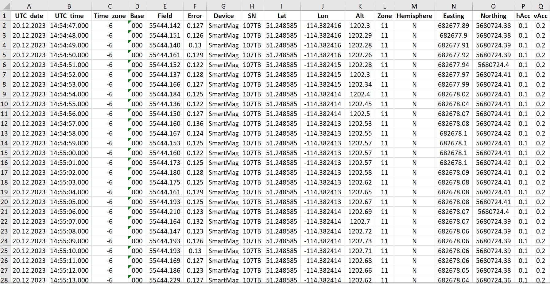
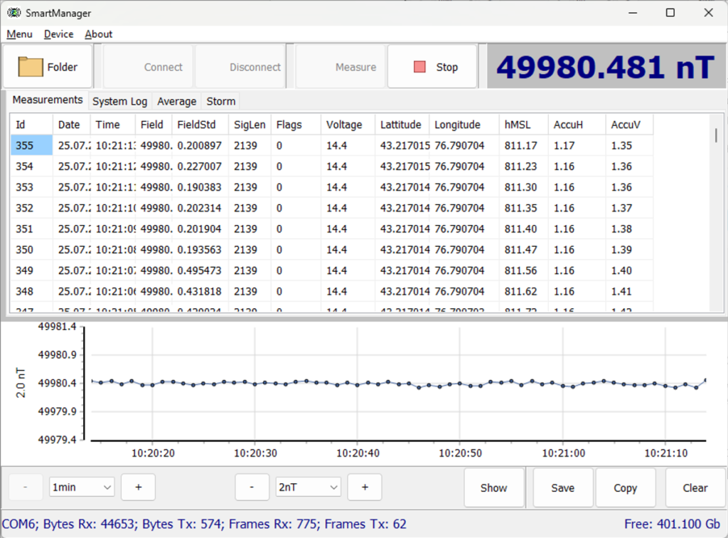
User can create project folders that can be used to divide survey sites or data collection days. All measurements are saved in a TXT file in the project folder. The file from each magnetometer has a name containing the serial number of the console, the code of the measurement mode and the number of connected sensors. The files have a homogeneous structure, i.e. each measurement in the file is a line that contains all necessary information: UTC date and time, time zone, base name, measured field, estimated error, sensor serial number, latitude and longitude in decimal degrees, altitude, UTM coordinates with automatic zone and hemisphere selection, horizontal and vertical accuracy.
Even if there are many operators working on a survey site at the same time, you will always be able to identify which instrument was used for each single measurement in the database.
Multi-sensor gradiometer
SmartMag supports the ability to link through a CAN FD interface to create a synchronized distributed network of magnetometers. This unique feature allows flexible creating of multi-sensor gradiometer with the necessary measurement base. You can connect up to 30 SmartMag’s to the a MaxiMag console or build a multi-sensor gradiometer with an almost unlimited number of sensors using CAN-Ethernet interface unit.
Metrology and noise protection – a guarantee of high accuracy
Every SmartMag is metrologically tested. We control the standard deviation of random error (noise), absolute accuracy and orientation error.
The robust algorithms allow to perform measurements at high level of industrial noise, in a city environment, or right under high-voltage powerlines.
Reliability and warranty
Our R&D specialists have extensive experience in performing geophysical surveys. We are well aware that such equipment must be reliable, and the service must be fast and convenient. We give 3 years warranty on all our magnetometers, and our technical support will promptly answer any of your questions. Our Overhauser sensors have the longest in the World lifecycle of more than 10 years. If you are still working with outdated magnetometers – take advantage of our trade-in offer and protect your projects from potential problems.
Built-in multi-band GNSS receiver with centimeter level accuracy
Time and coordinates are provided by the built-in multi-band GNSS receiver with PPK feature, that allows to achieve a centimeter level accuracy. SmartMag also has GNSS receiver mode and can be used as a GNSS base, rover or tracker without mag sensor connected during any geophysical applications. Stored RAW GNSS data could be easely converted to RINEX format.
SmartMag supports NMEA-0183 protocol and can be connected to external navigation devices via RS-232.
Important “little things”
- Carry-on size transportation case with whole equipment setup weight 7.5 kg only
- Keyboard with backlight
- More than 12 hours of continuous operation at -30°C and 23 hours at 20°C using the battery included
- Power cable for standard lead-acid battery included
- All rods are unified – a tripod or a long pole can be assembled
Operating modes:
- Base station with continuous measurements
- GNSS receiver mode with ability to collect RAW GNSS data for a centimeter level accuracy with base or rover modes
Application area:
- Base station for ground, drone, and airborne magnetic surveys
- Magnetic observatory
- Volcanology and earthquake prediction
- Operation with MaxiMag as a part of gradiometer for any type of ground magnetic surveys
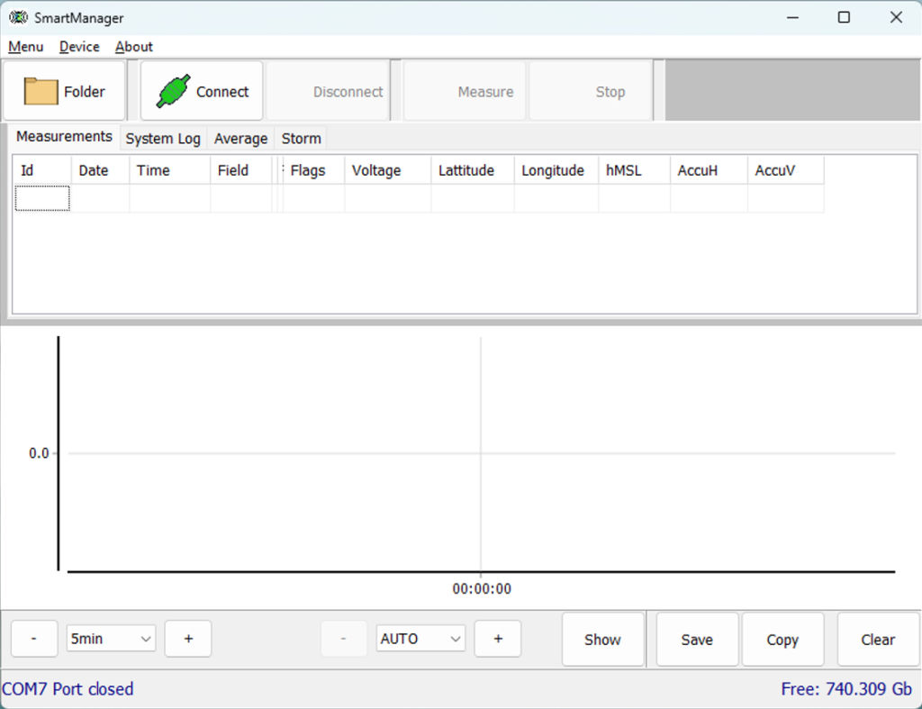
SmartManager software features:
- Magnetic field measurement mode control
- Visualization and quality control of measured data
- Visualization of the calculated measurement sensitivity
- Saving daily data files
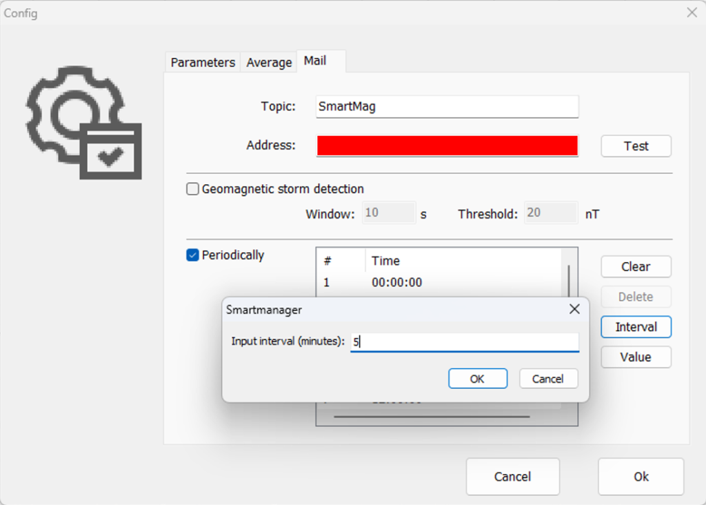
Capabilities of the CAN-Ethernet interface unit:
- Real-time data broadcasting via Ethernet to a PC or Internet
- Creating a synchronized distributed network of magnetometers
- Power adapter 100-240 VAC
- Backup power supply from external 12 V battery
Delivery set:
- SmartMag console with built-in multi-band GNSS receiver
- Overhauser sensor on rod
- External GNSS antenna on rod
- Rope locking tripod hitch
- Li-ion battery 14.8V/4Ah with charger
- Non-magnetic tripod
- Console bracket
- AGM battery power cable
- USB cable
- Smart base station carry-on case
Optional:
- SmartManager software
- CAN-Ethernet interface unit for connecting to PC/router
- RS-232 cable for real-time data broadcasting
- Power supply 100-240 VAC
- Additional Li-ion battery
| Type | Overhauser magnetometer |
| Number of sensors | up to 30 with MaxiMag console unlimited with optional CAN-Ethernet unit |
| Dynamic range | 20 000 to 120 000 nT |
| Absolute accuracy | 0.1 nT |
| Sensor sensitivity | 0.021 nT/√Hz rms 0.012 nT/√Hz rms (on request) |
| Resolution | 0.001 nT |
| Gradient tolerance | 30 000 nT/m |
| Sample rates | 0.2, 0.25, 0.5, 1 s and longer with 1 s step |
| Sensors stability | > 10 years |
| Additional sensors | IMU, compass |
| Interfaces | built-in: USB, RS-232, CAN FD optional: Ethernet (CAN-Ethernet interface unit required) |
| Maximum communication cable length | up to 6 km (CAN FD), up to 100 m (RS-232) |
| GNSS receiver | built-in and optional external |
| GNSS antenna | external |
| GNSS signals | GPS L1C/A and L2C; GLONASS L1OF and L2OF; Galileo E1B/C and E5b; BeiDou B1I and B2I; QZSS L1C/A, L1S and L2C. SBAS: WAAS, EGNOS, MSAS, GAGAN. |
| Connectors | 2 × CAN FD / RS232 / 12V, USB, external GNSS antenna, Overhauser sensor |
| Display | 160 × 128, OLED |
| Keypad | 6 buttons with backlight |
| Built-in memory | up to 32 Gb (microSD) |
| Power supply | 9.5-21 VDC, LiPo 3S/4S, Li-ion 3S/4S, LiFePo4 4S, or lead-acid battery 100-240 VAC, optional power supply required |
| Operating temperature | –40 to +60 °C |
| Battery included | 14.8 V, 4 A·h |
| Dimensions with connectors | Ø73×116 mm – sensor 125×100×35 mm – console |
| Item weight | 0.45 kg – console 1 kg – sensor on rod 0.7 – Li-ion battery |
| Weight of a set includes console, sensor, battery, tripod, and GNSS antenna | 3.1 kg |
| Delivery package size and weight | 55.8 × 35.5 × 19 cm, 7.5 kg |
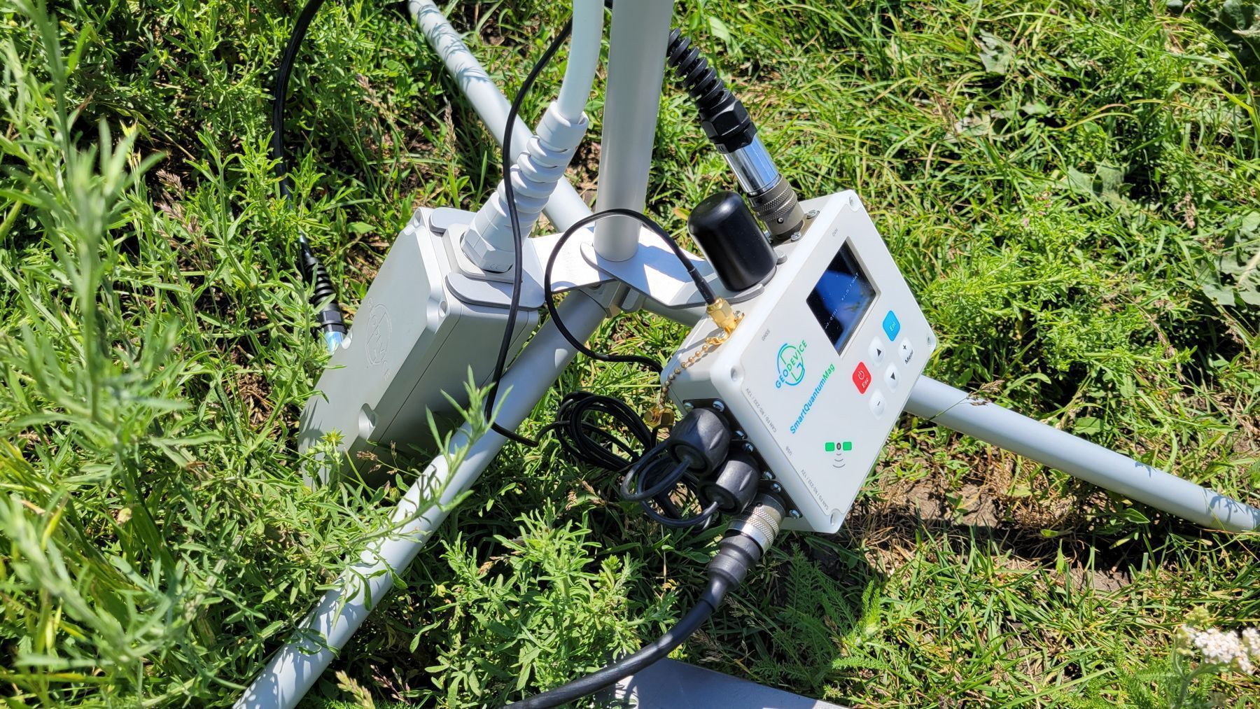
Cesium base station magnetometer SmartQuantumMag
- High sensitivity
- The World’s most compact Cs base station
- Up to 1 000 measurements per second
- Several SmartQuantumMag’s can be combined into a gradiometer
- Built-in multi-band GNSS receiver with PPK feature
SmartQuantumMag – the World’s most advanced and portable cesium (Cs) optical pumped magnetometer base station with sample rate up to 1 000 Hz. The complete ready to use set with accessories and battery fits in a carry-on size case and weighs only 8.5 kg. SmartQuantumMag can also be used as a part of a multi-sensor gradiometer, or even as a GNSS base and rover with centimeter accuracy in PPK mode. It is fully compatible with QuantumMag‘s console and can be applied for any type of ground magnetic surveys.
Easy-to-use console
The console enables easy configuration of operating modes, visual control of measured values and viewing of stored data from the built-in microSD card. Downloading data is performed via USB to a PC or smartphone. It is also possible to broadcast data via RS-232 or CAN ports in real time mode. The console is equipped with an OLED display (-40 ÷ +60 °C), built-in multi-band GNSS receiver with RAW GNSS data collection, and backlit keypad.
Magnetometer parts
The magnetometer package contains on the one hand a minimum number of unified parts to ease assembly and use, and on the other hand all the necessary components, so that you do not have to buy additional cables, a battery, or GNSS receiver without which you will not be able to work. Every magnetometer we ship is ready to use in its basic configuration. Options add functionality, but are not required by most users for standard operating scenarios.
Power supply
SmartQuantumMag operates over 9.5 hours of continuous measurements at -30°C from the battery included. At 20°C, the operating time increases to 16 hours. Continuous power supply in long term monitoring mode can be provided with a car battery, an optional low-noise power converter from 110/220VAC to 12VDC, or a solar panel.
Included LiFePo4 battery has the full temperature range from -40 up to +60°C and MSDS certificate for any kind of transportation.
SmartQuantumMag has no built-in batteries, which could complicate air transportation and sooner or later fail and require complex replacement.
Data format
User can create project folders that can be used to divide survey sites or data collection days. All measurements are saved in a TXT file in the project folder. The file from each magnetometer has a name containing the serial number of the console, the code of the measurement mode and the number of connected sensors. The files have a homogeneous structure, i.e. each measurement in the file is a line that contains all necessary information: UTC date and time, time zone, base name, measured field, estimated error, sensor serial number, latitude and longitude in decimal degrees, altitude, UTM coordinates with automatic zone and hemisphere selection, horizontal and vertical accuracy.
Even if there are many operators working on a survey site at the same time, you will always be able to identify which instrument was used for each single measurement in the database.
Multi-sensor gradiometer
SmartQuantumMag supports the ability to link through a CAN FD interface to create a synchronized distributed network of magnetometers. This unique feature allows flexible creating of multi-sensor gradiometer with the necessary measurement base. You can connect up to 6 SmartQuantumMag’s to the a MaxiMag console or build a multi-sensor gradiometer with an almost unlimited number of sensors using CAN-Ethernet interface unit.
Metrology and noise protection – a guarantee of high accuracy
Every SmartQuantumMag is metrologically tested. We control the standard deviation of random error (noise), absolute accuracy and heading error.
The robust algorithms allow to perform measurements at high level of industrial noise, in a city environment, or right under high-voltage powerlines.
Reliability and warranty
Our R&D specialists have extensive experience in performing geophysical surveys. We are well aware that such equipment must be reliable, and the service must be fast and convenient. We give 3 years warranty on all our magnetometers, and our technical support will promptly answer any of your questions. If you are still working with outdated magnetometers – take advantage of our trade-in offer and protect your projects from potential problems.
Built-in multi-band GNSS receiver with centimeter level accuracy
Time and coordinates are provided by the built-in multi-band GNSS receiver with PPK feature, which allows to achieve a centimeter level accuracy. SmartQuantumMag also has GNSS receiver mode and can be used as a GNSS base, rover or tracker without mag sensor connected during any geophysical applications. Stored RAW GNSS data could be easely converted to RINEX format.
SmartQuantumMag also supports NMEA-0183 protocol and can be connected to external navigation devices via RS-232.
Important “little things”
- Carry-on size transportation case with whole equipment setup weight 8.5 kg only
- Keyboard with backlight
- More than 9.5 hours of continuous operation at -30°C and 16 hours at 20°C using the battery included
- Power cable for standard lead-acid battery included
- All rods are unified – a tripod or a long pole can be assembled
Operating modes:
- Base station with continuous measurements
- Search mode for UXO objects detection or evaluation of a base station location
- GNSS receiver mode with ability to collect RAW GNSS data for a centimeter level accuracy with base or rover modes
Application area:
- Base station for ground, drone, and airborne magnetic surveys
- Volcanology and earthquake prediction
- Operation with QuantumMag as a part of gradiometer for any type of ground magnetic surveys
SmartManager software features
- Magnetic field measurement mode control
- Visualization and quality control of measured data
- Visualization of the calculated measurement sensitivity
- Saving daily data files
Capabilities of the CAN-Ethernet interface unit:
- Real-time data broadcasting via Ethernet to a PC or Internet
- Creating a synchronized distributed network of magnetometers
- Power adapter 100-240 VAC
- Backup power supply from external 12 V battery
Delivery set:
- SmartQuantumMag console with built-in multi-band GNSS receiver
- CMx sensor on rod
- Sensor electronics QuantumMag
- External GNSS antenna on rod
- Rope locking tripod hitch
- Lithium battery with charger
- Non-magnetic tripod
- Console and control unit brackets
- Sensor-to-console cable
- AGM battery power cable
- USB cable
- Smart base station carry-on case
Optional:
- SmartManager software
- CAN-Ethernet interface unit for connecting to PC/router
- RS-232 cable for real-time data broadcasting
- Power supply 100-240 VAC
| Type | Optical pumped Cs magnetometer |
| Number of sensors | up to 6 with MaxiMag console unlimited with optional CAN-Ethernet unit |
| Dynamic range | 15 000 to 110 000 nT |
| Absolute accuracy | 2 nT |
| Sensor sensitivity | 0.002 nT/√Hz rms 0.021 nT/√Hz rms (on request) |
| Resolution | 0.001 nT |
| Gradient tolerance | 20 000 nT/m |
| Sample rates | up to 1 000 Hz |
| Additional sensors | IMU, compass |
| Interfaces | built-in: USB, RS-232, CAN FD. optional: Ethernet (CAN-Ethernet interface unit required) |
| Maximum communication cable length | up to 6 km (CAN FD), up to 100 m (RS-232) |
| GNSS receiver | built-in and optional external |
| GNSS antenna | built-in and optional external |
| GNSS signals | GPS L1C/A and L2C; GLONASS L1OF and L2OF; Galileo E1B/C and E5b; BeiDou B1I and B2I; QZSS L1C/A, L1S and L2C. SBAS: WAAS, EGNOS, MSAS, GAGAN. |
| Connectors | 2 × CAN FD / RS232 / 12V, USB, external GNSS antenna, Cesium sensor |
| Display | 160 × 128, OLED |
| Keypad | 6 buttons with backlight |
| Built-in memory | up to 32 Gb (microSD) – more than 250,000,000 readings |
| Power supply | 9.5-21 VDC, LiPo 3S/4S, Li-ion 3S/4S, LiFePo4 4S, or lead-acid battery |
| Operating temperature | –40 to +60 °C |
| Battery included | 12.8 V, 7.5 A·h |
| Dimensions with connectors | Ø82×120 mm – sensor 125×100×35 mm – console |
| Item weight | 0.4 kg – console 1.2 kg – sensor on rod with sensor electronics |
| Weight of a set includes console, sensor, battery, tripod, and GNSS antenna | 4 kg |
| Delivery package size and weight | 55.8 × 35.5 × 19 cm, 8.5 kg |
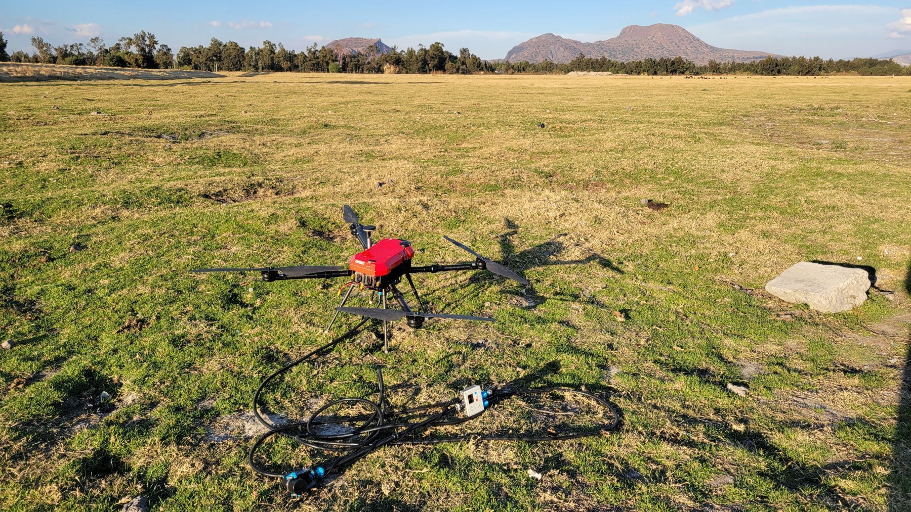
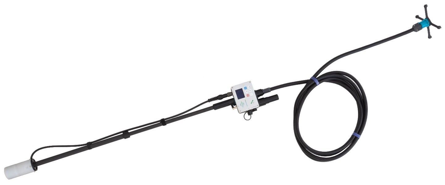
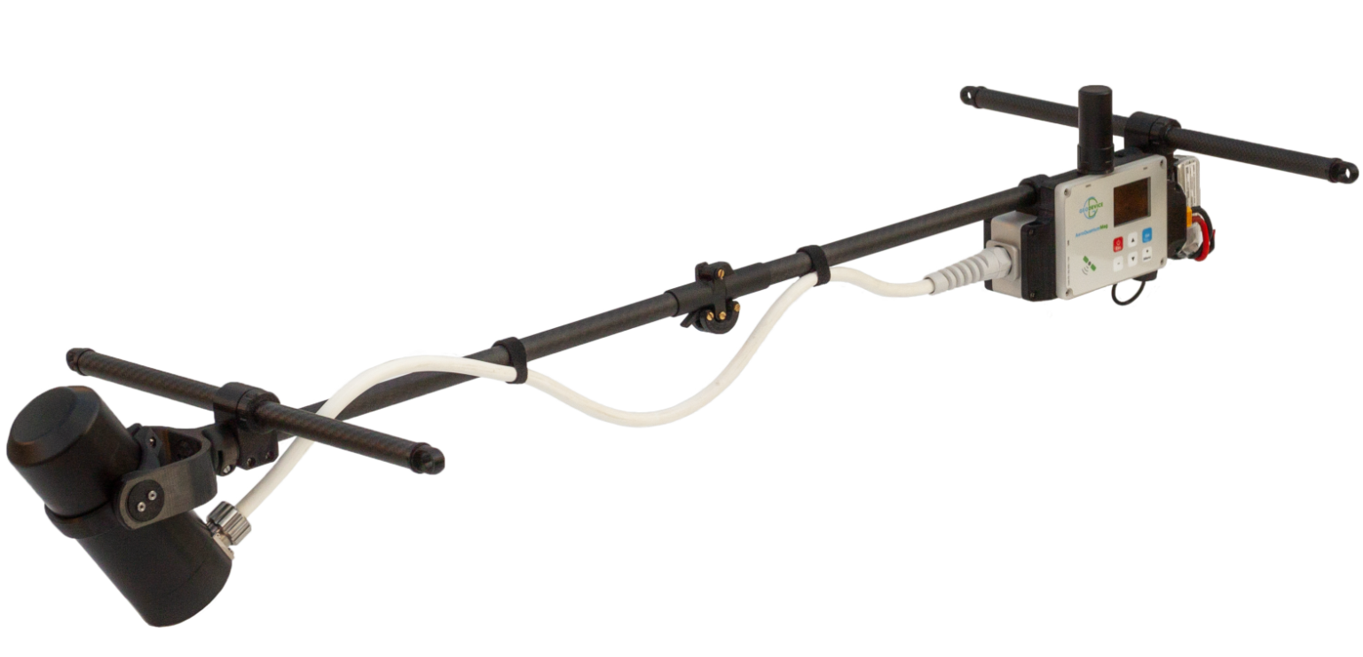
Overhauser drone magnetometer AeroSmartMag
- High sensitivity
- Very affordable price and easy to operate
- No sensor orientation and heating required
- Very low power consumption
- Built-in high-precision GNSS receiver
AeroSmartMag is an evolution of the SmartMag platform – the world’s most advanced and portable magnetometer, based on Overhauser effect. We’ve lightened the sensor, developed a lighter frame, and achieved a fully assembled weight of less than 1.2 kg, battery included. Optimized design in combination with dedicated algorithms, aims to eliminate sway noise during flight. The Overhauser sensor does not require orientation or warm-up before flight. All this, combined with very low power consumption, makes AeroSmartMag the easiest-to-use drone magnetometer in the industry. Its affordable price positions AeroSmartMag as a revolutionary product.
Easy-to-use drone magnetometer
AeroSmartMag is equipped with very user friendly console – simply use the buttons to select the measurement parameters and press Start. After that, you don’t need to do anything for up to 5 hours – just change the drone’s batteries for each new flight. All measurements are saved on the built-in microSD card. Data is downloaded via USB to a PC or smartphone. The remote control is equipped with an OLED display (-40 ÷ +60 °C), a built-in multi-band GNSS receiver with the ability to collect RAW GNSS data and a backlit keyboard.
The foldable magnetometer frame reduces the device size during transportation, and also absorbs the shock and reduces damage if the drone falls. We use mostly 3D printed hardware parts, so if there is a possible failure off any part, we will send you models to print the required components on a nearby printer.
Power supply
AeroSmartMag operates up to 5 hours of continuous measurements with very lightweight battery included. You can also connect a more powerful battery if you want to use the magnetometer as a base station or GNSS receiver.
Data format
User can create project folders that can be used to divide survey sites or data collection days. All measurements are saved in a TXT file in the project folder. The file from each magnetometer has a name containing the serial number of the console, the code of the measurement mode and the number of connected sensors. The files have a homogeneous structure, i.e. each measurement in the file is a line that contains all necessary information: UTC date and time, time zone, flight number or base name, measured field, estimated error, sensor serial number, latitude and longitude in decimal degrees, altitude, UTM coordinates with automatic zone and hemisphere selection, horizontal and vertical accuracy. Raw GNSS data is stored in a separate file with the same name.
Even if there are many operators working on a survey site at the same time, you will always be able to identify which instrument was used for each single measurement in the database.
Metrology and noise protection – a guarantee of high accuracy
Every AeroSmartMag is metrologically tested. We control the standard deviation of random error (noise), absolute accuracy and heading error.
The robust algorithms allow to perform measurements at high level of industrial noise, in a city environment, or right under/up high-voltage powerlines.
Built-in multi-band GNSS receiver with centimeter level accuracy
Time and coordinates are provided by the built-in multi-band GNSS receiver with PPK feature, which allows to achieve a centimeter level accuracy. AeroSmartMag also has GNSS receiver mode and can be used as a GNSS base, rover or tracker without mag sensor connected during any geophysical applications. Stored RAW GNSS data could be easily converted to RINEX format.
Reliability and warranty
Our R&D specialists have extensive experience in performing geophysical surveys. We are well aware that such equipment must be reliable, and the service must be fast and convenient. We give 3 years warranty on all our magnetometers, and our technical support will promptly answer any of your questions. Our Overhauser sensors have the longest in the World lifecycle of more than 10 years. If you are still working with outdated magnetometers – take advantage of our trade-in offer and protect your projects from potential problems.
Important “little things”
- Fairings have a golf ball shape to optimize turbulent flow
- Keyboard with backlight
- Up to 5 hours of continuous operation with the battery included
- Could be used as a base station or a GNSS receiver with centimeter accuracy
Operating mode
- Drone magnetic survey with simultaneous recording of RAW GNSS data
- Base station with continuous measurements
- GNSS receiver mode with ability to collect RAW GNSS data for a centimeter level accuracy with base or rover modes

Application area
- Mineral exploration
- UXO detection
- Regional geological surveys
- Engineering surveys
- Pipeline mapping
- Archaeological studies
- Oil and gas exploration
Delivery set:
- AeroSmartMag console with built-in multi-band GNSS receiver
- Portable Overhauser sensor on carbon rod
- External helical GNSS antenna
- Suspension rope
- USB cable
- Transportation case
Optional:
- LiPo 4S 14.8V 1300mAh battery (2 pcs.) with charger
- Suspension bracket for DJI Matrice M300/M350/M400
- Suspension bracket for customer drone
- Non-magnetic tripod with bracket for base station mode
- Li-ion battery 14.8V/4Ah with charger for base station mode
| Type | Overhauser magnetometer |
| Number of sensors | 1 |
| Dynamic range | 20 000 to 120 000 nT |
| Absolute accuracy | 0.1 nT |
| Sensor sensitivity | 0.021 nT/√Hz rms |
| Resolution | 0.001 nT |
| Gradient tolerance | 30 000 nT/m |
| Sample rates | Drone mode: 0.2, 0.25, 0.5, 1 s Base station: 0.2, 0.25, 0.5, 1 s and longer with 1 s step |
| Sensors stability | > 10 years |
| Additional sensors | IMU, compass |
| Interfaces | built-in: USB, RS-232, CAN FD |
| GNSS receiver | built-in |
| GNSS antenna | external |
| GNSS signals | GPS L1C/A and L2C; GLONASS L1OF and L2OF; Galileo E1B/C and E5b; BeiDou B1I and B2I; QZSS L1C/A, L1S and L2C. SBAS: WAAS, EGNOS, MSAS, GAGAN. |
| Connectors | 1 × CAN FD / RS232 / 12V, USB, external GNSS antenna, Overhauser sensor |
| Display | 160 × 128, OLED |
| Keypad | 6 buttons with backlight |
| Built-in memory | up to 32 Gb (microSD) |
| Power supply | 9.5-21 VDC, LiPo 3S/4S, Li-ion 3S/4S, LiFePo4 4S, or lead-acid battery |
| Operating temperature | –40 to +60 °C |
| Battery | LiPo 4S 14.8V 1.3Ah |
| Item weight | 1.2 kg – fully assembled with battery |
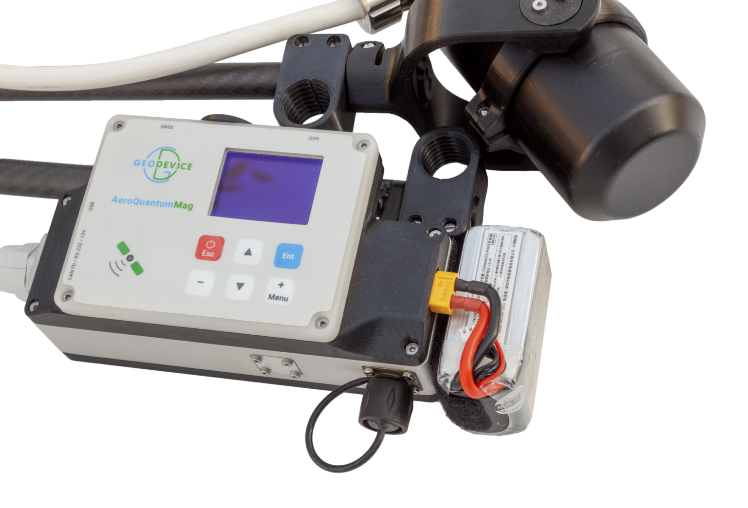
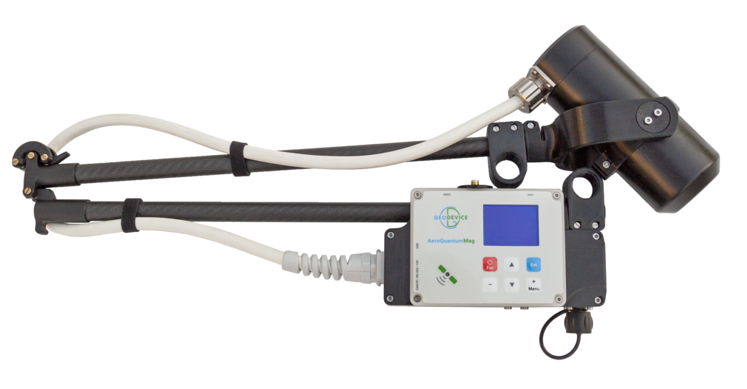
Quantum drone magnetometer with cesium sensor AeroQuantumMag
- Highest accuracy and sensitivity
- Up to 1 000 measurements per second
- Built-in GNSS receiver
- Affordable price and easy-to-use
AeroQuantumMag is designed to efficiently perform magnetic survey work using drone. The device is featuring a high measurement speed (up to 1 000 Hz) and a sensitivity of 0.002 nT/√Hz rms. Aerodynamic body with carbon fiber frame weighs only 1.3 kg with battery. The low weight increases the flight time of the drone. The magnetometer requires no data exchange with the UAV and uses its own battery, so it can be used with any UAV.
Easy-to-use drone magnetometer
AeroQuantumtMag is equipped with a user-friendly remote control – select the desired survey parameters and press Start. All measurements are saved to the built-in microSD card. Data is quickly downloaded to a PC or smartphone via USB. The remote control is equipped with an OLED display that operates in a wide temperature range (−40 ÷ +60 °C), built-in multi-frequency GNSS receiver, with RAW GNSS data recording and backlit keypad.
Power supply
The lightweight 1300 mAh LiPo4 4S battery provides up to 1.5 hours of continuous measurement time (at 20°C), which exceeds the flight time of a standard light drone by 2-3 times. If necessary, the device can also be used as a magnetic variation station or GNSS tracker with a larger battery.
Data format
User can create project folders that can be used to divide survey sites or data collection days. All measurements are saved in a TXT file in the project folder. The file from each magnetometer has a name containing the serial number of the console, the code of the measurement mode and the number of connected sensors. The files have a homogeneous structure, i.e. each measurement in the file is a line that contains all necessary information: UTC date and time, time zone, flight number or base name, measured field, estimated error, sensor serial number, latitude and longitude in decimal degrees, altitude, UTM coordinates with automatic zone and hemisphere selection, horizontal and vertical accuracy. Raw GNSS data is stored in a separate file with the same name and can be easily converted to RINEX. Even if there are many operators working on a survey site at the same time, you will always be able to identify which instrument was used for each single measurement in the database.
Metrology and noise protection – a guarantee of high accuracy
Every AeroQuantumMag is metrologically tested. We control the standard deviation of random error (noise), absolute accuracy and heading error. The robust algorithms allow to perform measurements at high level of industrial noise, in a city environment, or right under/up high-voltage powerlines.
Built-in multi-band GNSS receiver with centimeter level accuracy
Time and coordinates are provided by the built-in multi-band GNSS receiver with PPK feature, which allows to achieve a centimeter level accuracy. AeroQuantumMag also has GNSS receiver mode and can be used as a GNSS base, rover or tracker without mag sensor connected during any geophysical applications. Stored RAW GNSS data could be easily converted to RINEX format.
Reliability and warranty
Our R&D specialists have extensive experience in performing geophysical surveys. We are well aware that such equipment must be reliable, and the service must be fast and convenient. We give 3 years warranty on all our magnetometers, and our technical support will promptly answer any of your questions. If you are still working with outdated magnetometers – take advantage of our trade-in offer and protect your projects from potential problems.
Important “little things”
- Keyboard with backlight
- Could be used as a base station or a GNSS receiver with centimeter accuracy
- Type-C adapter for data transfer to smartphone
- High-quality GNSS module with a wide range of capabilities
- Versatility – use AeroQuantumMag as a drone magnetometer, base station, GNSS base, rover or tracker
Operating mode
- Drone magnetic survey with simultaneous recording of RAW GNSS data
- Base station with continuous measurements
- GNSS receiver mode with ability to collect RAW GNSS data for a centimeter level accuracy with base or rover modes
Application area
- Mineral exploration
- UXO detection
- Regional geological surveys
- Engineering surveys
- Pipeline mapping
- Archaeological studies
- Oil and gas exploration
Delivery set:
- Console with built-in multi-band GNSS receiver
- Portable Quantum (Cs) sensor on carbon rod
- Lightweight helical GNSS antenna
- Suspension rope
- USB cable
- Transportation case
Optional:
- Suspension bracket for DJI Matrice M300/M350/M400
- Suspension bracket for customer drone
- LiPo 4S 14.8V 1550mAh battery (2 pcs) with charger
- Non-magnetic tripod with bracket for base station mode
| CMx | CSMx | |
| Type | Optical pumped Cs magnetometer | Self-oscillation split-beam Cesium vapor (non-radioactive Cs-133) optical pumped |
| Sensor sensitivity | 0.002 nT /√Hz | 0.0006 nT /√Hz |
| Heading error | <1.5 nT (±20°) | <± 0.2nT in ±35° range from optimum angle of 45°, operating zones 10-80° and 100-170° |
| Sample rate | 1 000 Hz | 1 280 Hz |
| Dynamic range | 15 000 ÷ 110 000 nT | |
| Absolute accuracy | <2 nT | |
| Resolution | 0.001 nT | |
| Optimal angle between the sensor axis and the field vector | 45° | |
| Operating range of inclination relative to the optimum angle | ± 30° | |
| Gradient tolerance | 20 000 nT/m | |
| Interfaces | USB | |
| GNSS receiver | GNSS signals: GPS L1C/A and L2C; GLONASS L1OF and L2OF; Galileo E1B/C and E5b; BeiDou B1I and B2I; QZSS L1C/A, L1S and L2C. SBAS: WAAS, EGNOS, MSAS, GAGAN. | |
| Connectors | XT60, USB, external GNSS antenna | |
| Display | 160 × 128, OLED | |
| Keypad | 6 buttons | |
| Built-in memory | up to 32 Gb (microSD) | |
| Power supply | 9.5-21 VDC, LiPo 3S/4S, Li-ion 3S/4S, LiFePo4 4S, or lead-acid battery | |
| Operating temperature | –40 ÷ +50 °C | |
| Additional sensors | IMU, compass | |
| Dimensions | Ø 84×115 mm sensor172×63×108 mm console | |
| Weight | 1.2 kg – magnetometer0.17 kg – LiPo 4S 1550 mAh battery | |
| Delivery package size and weight | 119.7 × 48.7 × 17.5 cm, 11.5 kg | |
Cesium airborne magnetometer CSMx
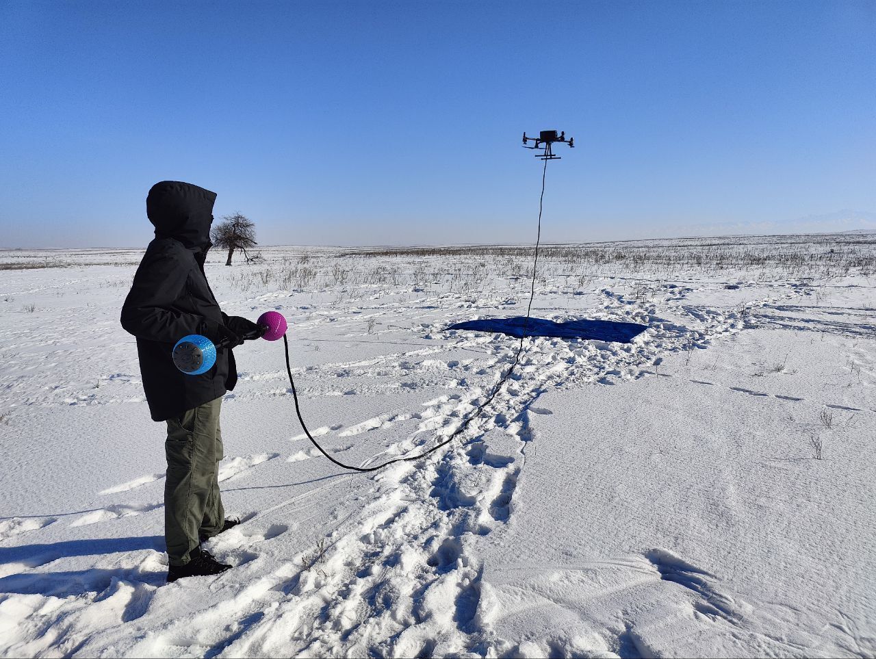
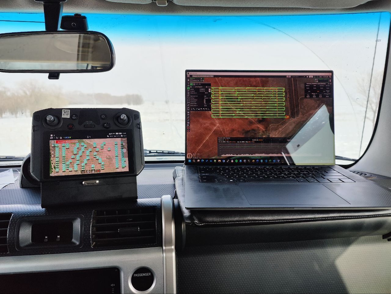
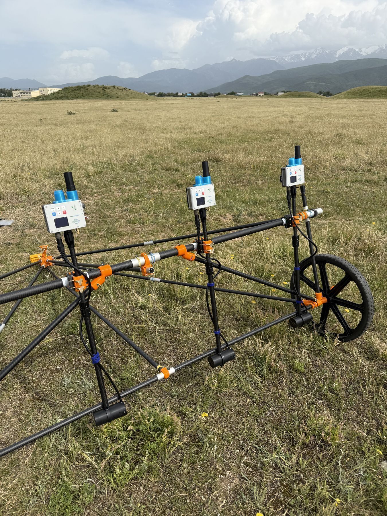
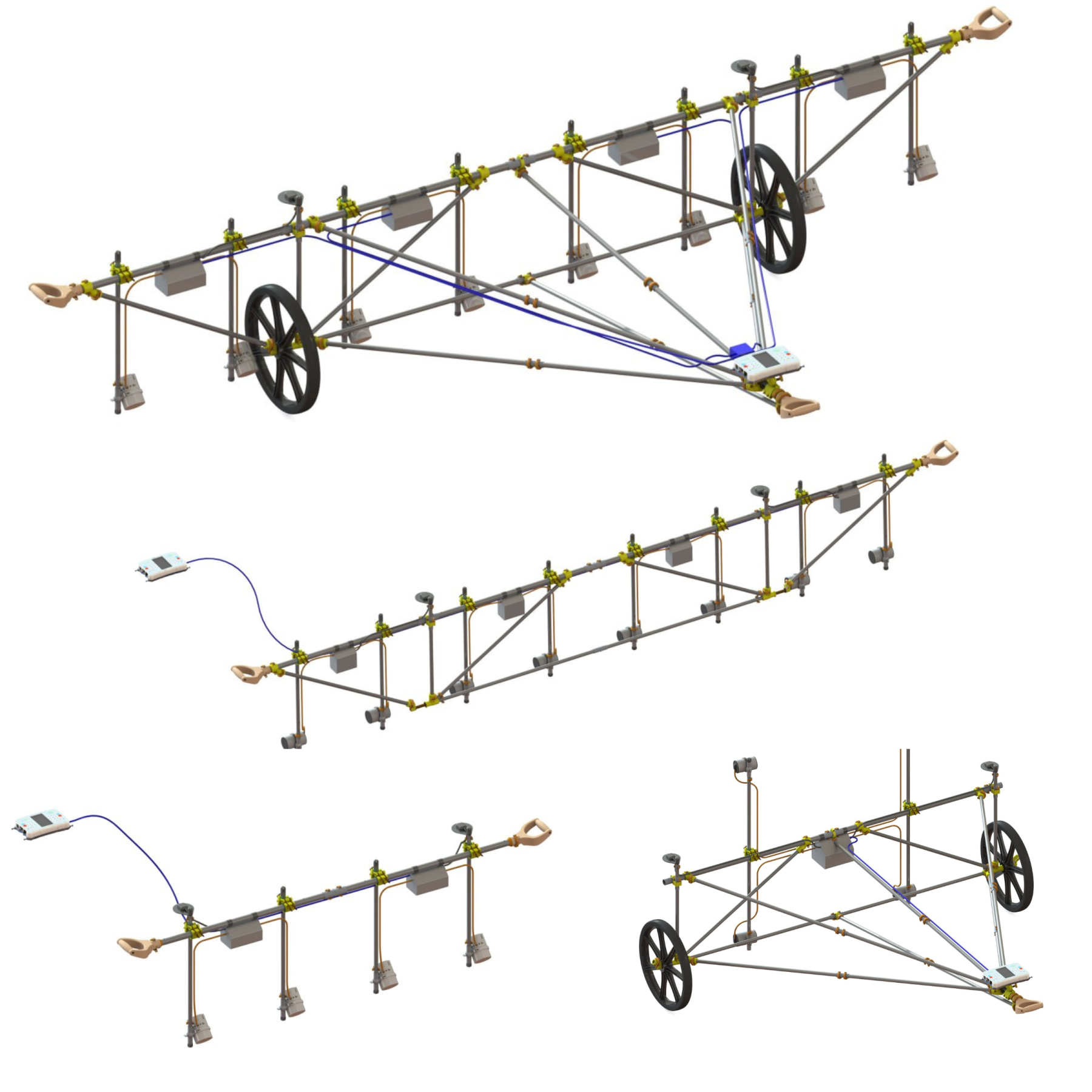
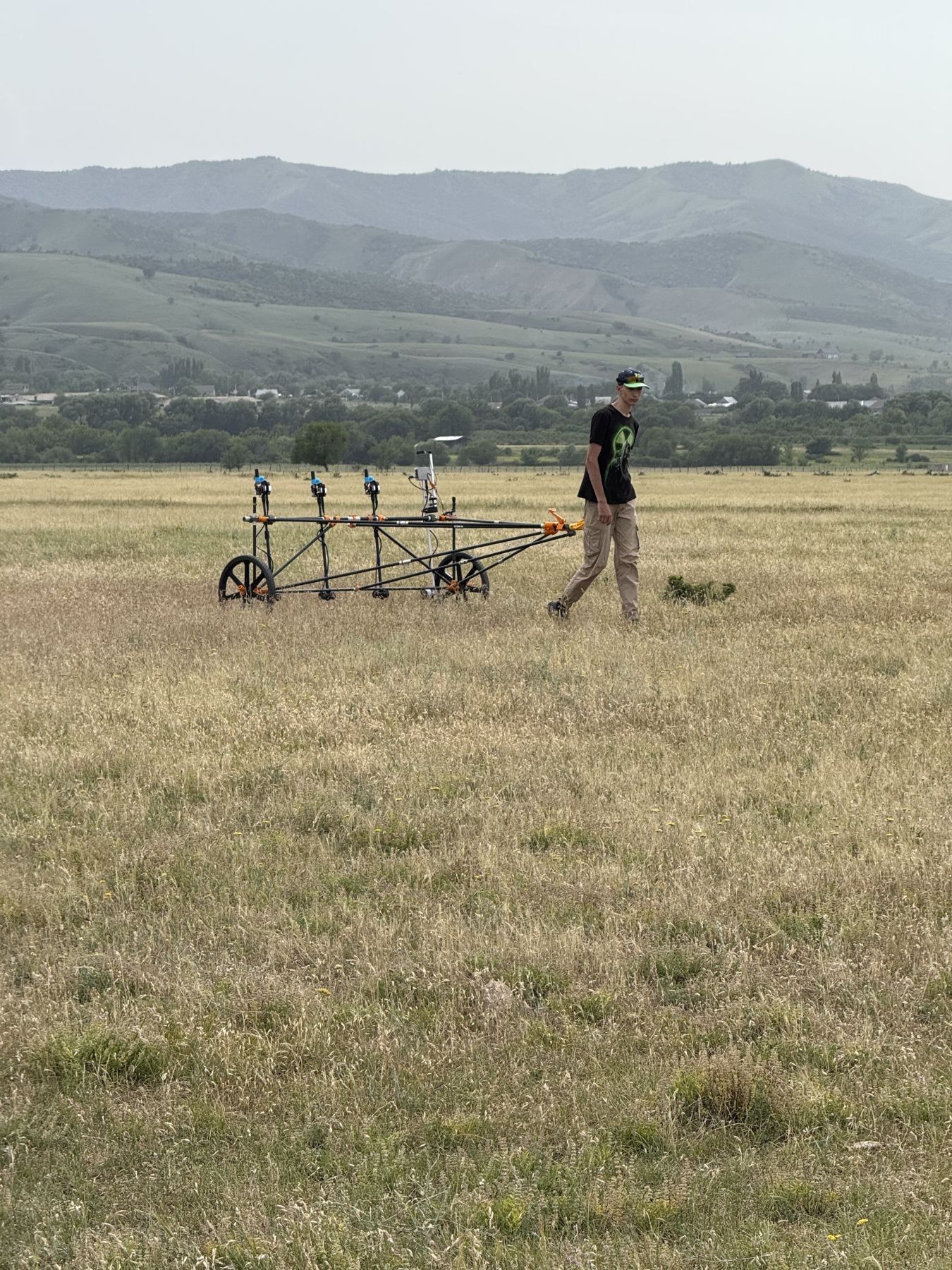
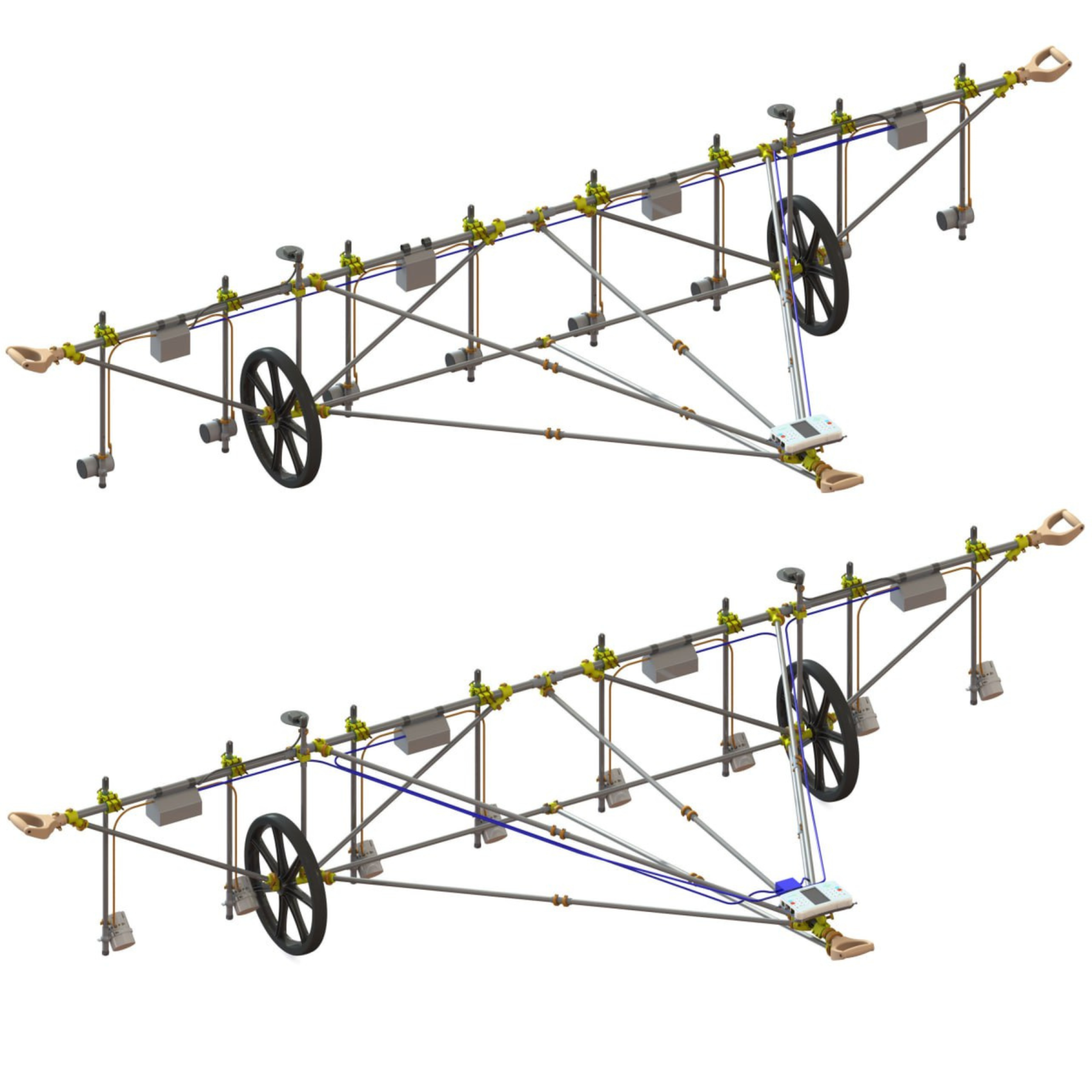
MagCart – non-magnetic multi-sensor gradiometer cart for archaeological studies
Equipment & Software for Geophysical Surveys: Design, Manufacture, Support, Supply
GEODEVICE is a group of specialized companies that develops, manufactures, and supplies
advanced geophysical equipment and software for a wide range of applications, from land-
based surveys to marine and borehole explorations.
The key areas of GEODEVICE developments are high and ultra-high resolution marine seismic,
borehole seismic, land, drone and marine magnetic.
The focus is on a broad range of industries and scientific fields, providing tailored solutions for:
- Geotechnical Monitoring
- Engineering Surveys
- Environmental Surveys
- Archaeological Surveys
- Geophysical Support for Geological Exploration
Let’s Connect
Need assistance? Get in touch with our team.