GEOELECTRICAL & ELECTROMAGNETIC
ALMAZ Marine – aquatic system for continuous DC / AC sounding
- 32 high-precision channels
- Saving raw full-waveform data
- 3000 W powerful transmitter for up to 10 A
- Onboard GNSS receiver and tail buoy
- Optional switchbox for bottom observation
- Optional 50A transmitter
- Surface, bottom and deep-towed streamers
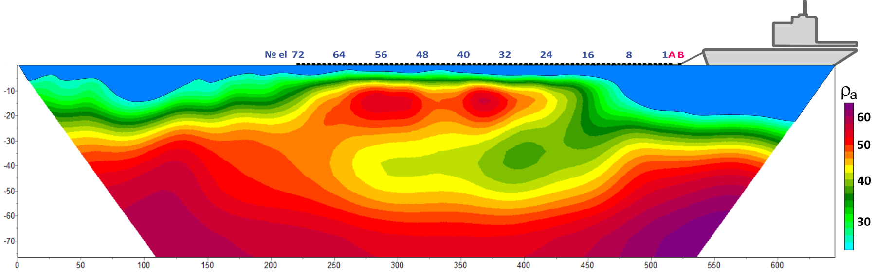
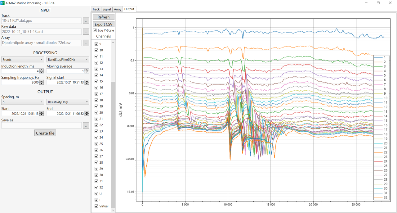
ALMAZ Marine is the most modern system in the World for performing continuous aquatic sounding on DC or recording EM processes with 72-electrode towing array. A unique 3 kW generator allows using current up to 10 A, and when using an external DC source, 50 A current switching is available (optional). The built-in switchbox is designed to select one of three available array types. This approach, together with synchronous data recording on 32 channels, provides the highest possible resolution and depth of study achieveble with electrical tomography method – up to ~100-150 m (array with 5 m electrode spacing) both in fresh and marine water with a bottom depth of up to a few tens of meters.
Receivers
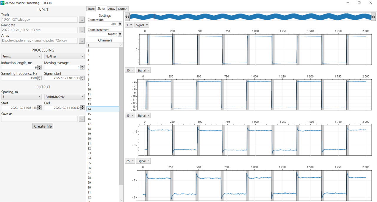
ALMAZ Marine has 32 precision channels with constant self-potential (SP) compensation. Another two channels are reserved for recording of current and signal voltage measurement. All that raw data can be recorded with sampling rate up to 3,600 Hz (7,200 Hz on request) per channel for further processing. Each receiver is isolated and has a filter. ALMAZ receiver is among the best on the market and provides minimal noise and good phase characteristics stability.
Transmitter
We have developed a 3 000 W power transmitter designed for aquatic applications. It works with currents up to 10 A and voltages up to 300 V (up to 600 V peak-to-peak) using a meander or paused meander waveform. These parameters provide measurable signal on all channels with standard 5-meter electrode spacing streamers, even in the marine area. ALMAZ Marine can also work with an external transmitter with continuous current recording in the line.
Arrays and streamers
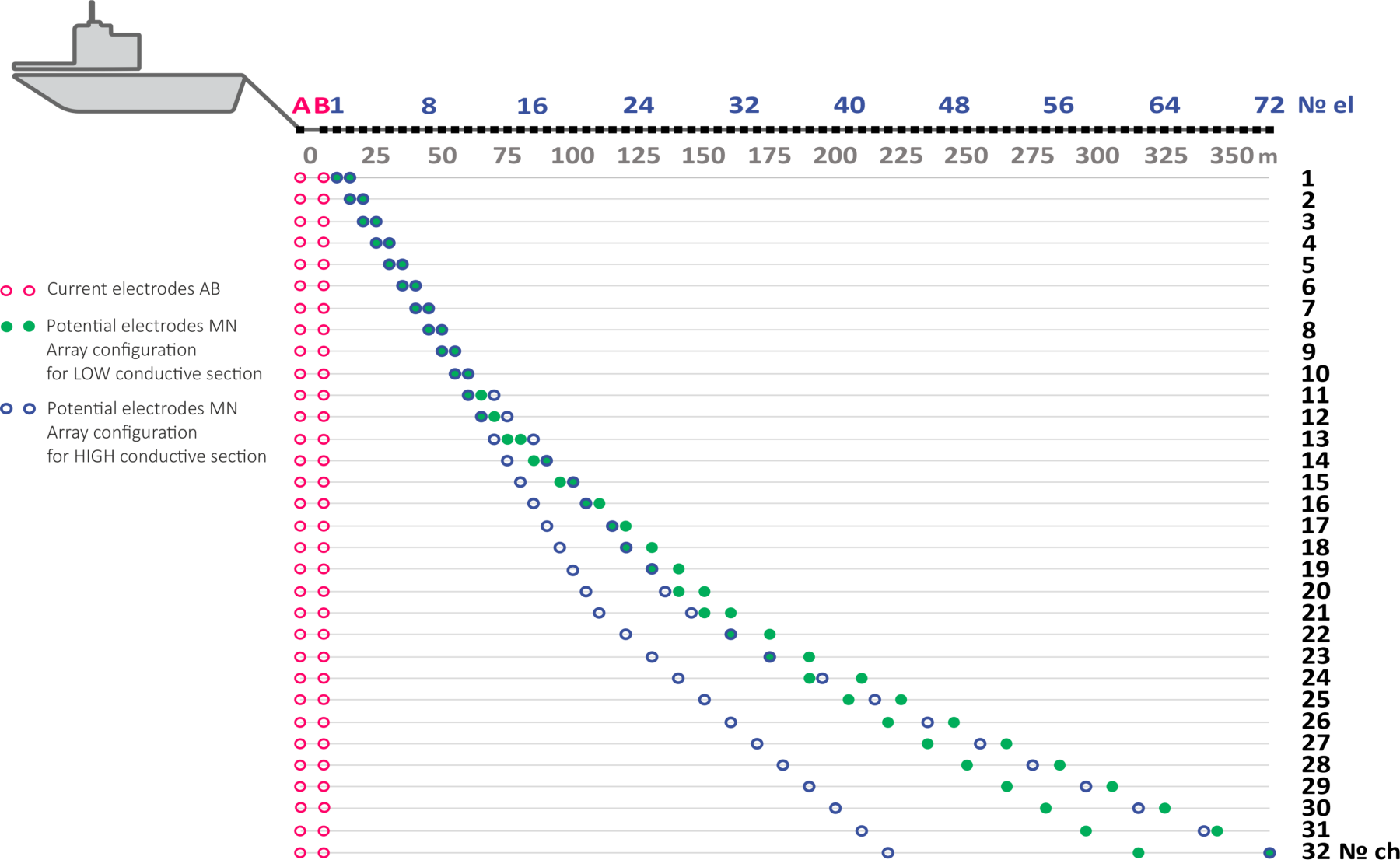
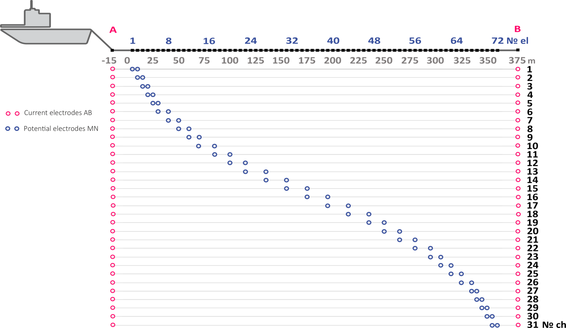
ALMAZ Marine supports two dipole-dipole and one gradient array. The first type is intended to get the best resolution and depth in freshwater areas or high resistivity water. Gradient array provides a significantly higher signal level at the receiver dipoles, so it is preferable in salty or heavily polluted (with resistivity starting from 0.2 Ohm∙m) water areas. Both arrays are designed to provide optimal data coverage of the pseudosection.
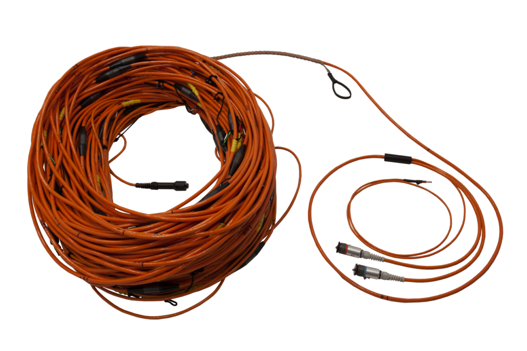
ALMAZ Marine is supplied with 72-electrode streamer. The standard spacing between the electrodes along the streamer is 2 – 5 meters. Transmitter electrodes are located outside the receiving streamer, and their spacing is easily adjustable. Thus, the length of an array varies from 146 to >365 m, which allows to estimate the depth of the survey in average geological conditions from 35 to 150 m, respectively.
Streamer for near-surface towing has floats, that allow to control immersion depth while keeping the streamer visible while towing. The floats can be detached, so that the streamer is laid on the bottom, connected to an optional switchbox, and bottom ERT observations can be performed. Deep-towed streamers with built-in pressure sensors, magnetic compasses and INS are also available, which allows to calculate array positioning precisely. Bottom towing is another option which increases the resolution and depth of surveys, while maintaining a high speed of surveying.
Optional powerful current switches
For electromagnetic soundings in salt waters, currents of several hundreds od Amperes are required. If your project requres such powerful switchbox, contact us and we will be happy to assist.
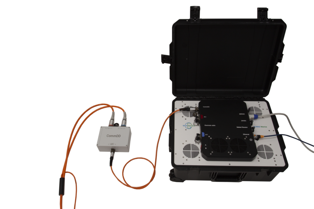
Optional ERT switchbox for bottom observations
The towed cable included in the delivery set can be used for bottom detailed observations with electrode switching using CommDD2.
Optional GNSS receiver
When surveying with a towed streamer, it is crucial to record coordinates in real time using GNSS receivers. We supply sealed GNSS receivers that can be located on the vessel and on the end buoy.
Software
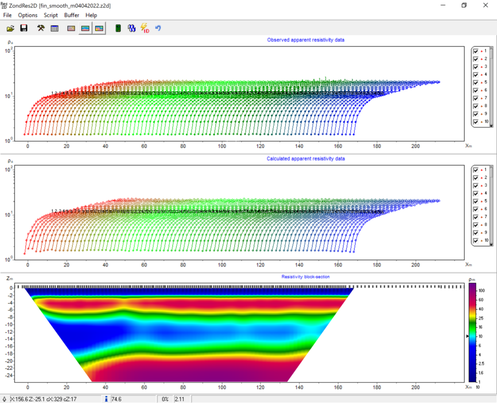
- ALMAZ Marine is Windows laptop-controlled
- Easy measurement mode setup
- Real time collected data visualization
- Saving raw and / or processed data for subsequent inversion
Reliability and warranty
Our R&D specialists have extensive experience in performing geophysical surveys. We are well aware that such equipment must be reliable, and the service must be fast and comfortable. We give 3 years warranty on ALMAZ Marine systems, and our technical support team will promptly answer any of your questions. If you are still working with outdated equipment – take advantage of our trade-in offer and protect your projects from potential problems.
Important “little things”:
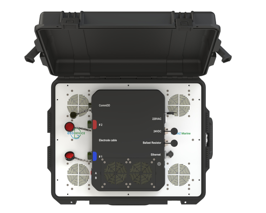
- All connectors are installed in the central part of the panel – this means that during transportation they will be perfectly protected by a sealed shock-resistant case
- Towed streamers are reinforced with Kevlar
Application area:
- Engineering surveys
- Solid minerals exploration
- Building materials exploration
- Locating gas pockets in gas-saturated silts
- Underwater volcanoes and hydrothermal vents study
- Gas hydrates exploration
- Environmental studies
- Permafrost mapping
- Locating freshwater sources in the sea (underwater discharge of groundwater)
- Determining sub-bottom geology for dredging purposes
- Variations in the salinity of the water column
- Characterizing the sub-bottom of estuaries
Delivery set:
- ALMAZ Marine unit
- Software for survey planning and data collection
- Towed streamer with a set of current electrodes and floats
Optional:
On request it is possible to customize ALMAZ Marine unit for a submersible version in a sealed container for installation on controlled underwater vehicles or with other additional features. In order to properly formulate technical specs of your system, please contact us in any way indicated on the website.
| Number of channels | 32 |
| Number of electrodes | 72 |
| Electrode spacing | 2, 2.5, 4, or 5 m |
| Supported arrays | Two dipole-dipole and one gradient |
| Maximum output power | 3 000 W (power supply 220 VAC 50/60Hz) 5 000 W (up to 8 12V batteries in series or optional AC/DC converter) |
| Maximum output current | 10 A (power supply 220 VAC 50/60Hz) 50 A (up to 8 12V batteries in series or optional AC/DC converter) |
| Maximum output voltage | 600 Vp-p (power supply 220 VAC 50/60Hz) 200 Vp-p (up to 8 12V batteries in series or optional AC/DC converter) |
| Output current waveform | ON+/ON- or ON+/OFF/ON-/OFF |
| Transmitter frequency | 0 – 72 Hz Optional: 0 – 50 kHz |
| Measurement range of channels | Channel 1: ±20 V Channels 2-32: ±10 V |
| Measurement resolution | 100 nV, depends on voltage level |
| Input impedance | 5 MOhm |
| Total accuracy | better than 1 % |
| Sampling rate | 3 600 Hz Optional: 7 200 Hz |
| Measured and calculated values | Voltage, current, apparent resistivity, percent frequency effect, chargeability, self-potential, electrode coordinates |
| Data transfer | Ethernet 1Gb |
| GNSS receiver (optional) | External with RS-232 (NMEA 0183) connection with the ability to record RAW data.Received signals: GPS L1C/A and L2C; GLONASS L1OF and L2OF; Galileo E1B/C and E5b; BeiDou B1I and B2I; QZSS L1C/A, L1S, and L2C. SBAS: WAAS, EGNOS, MSAS, GAGAN. |
| Power supply | 220 VAC, 50/60 Hz |
| Operating temperature range | -20 ÷ +60 °C |
| Unit dimensions | 625×500×297 mm |
| Measuring unit weight | 24 kg |
Solid non-polarizable electrodes
Equipment & Software for Geophysical Surveys: Design, Manufacture, Support, Supply
GEODEVICE is a group of specialized companies that develops, manufactures, and supplies
advanced geophysical equipment and software for a wide range of applications, from land-
based surveys to marine and borehole explorations.
The key areas of GEODEVICE developments are high and ultra-high resolution marine seismic,
borehole seismic, land, drone and marine magnetic.
The focus is on a broad range of industries and scientific fields, providing tailored solutions for:
- Geotechnical Monitoring
- Engineering Surveys
- Environmental Surveys
- Archaeological Surveys
- Geophysical Support for Geological Exploration
Let’s Connect
Need assistance? Get in touch with our team.